
Beaucourt
| Beaucourt | ||
|---|---|---|
.svg)
|
|
|
| region | Bourgogne-Franche-Comté | |
| Department | Territoire de Belfort | |
| Arrondissement | Belfort | |
| Canton | Dent | |
| Community association | South Territoire | |
| Coordinates | 47 ° 29 ′ N , 6 ° 56 ′ E | |
| height | 375-575 m | |
| surface | 4.95 km 2 | |
| Residents | 5,007 (January 1, 2017) | |
| Population density | 1,012 inhabitants / km 2 | |
| Post Code | 90500 | |
| INSEE code | 90009 | |
| Website | http://www.beaucourt.fr/ | |
 Beaucourt Town Hall |
||

Beaucourt is a commune in the department Territoire de Belfort in the region Bourgogne Franche-Comté . It belongs to the Arrondissement of Belfort .
geography
Beaucourt is located at 425 m, about ten kilometers east-southeast of the city of Montbéliard (as the crow flies). The municipality extends in the northern foothills of the Jura , in a hollow in the Tafeljura plateau , at the northern foot of the Grammont, near the border with Switzerland .
The area of the 4.95 km² large municipality covers a section of the northern French Jura. The central part of the area is occupied by a valley basin that begins south of the old town center and opens north to the valley of the village stream of Dampierre. The approximately 200 m wide, flat valley low lies at around 420 m and is flanked on both sides by around 20 to 30 m high slopes. These lead over to the adjacent plateaus, which are on average 450 m. They are largely built over. In the west, the border runs above the Mulde von Dasle and along the Bois de Meilloncourt , while the eastern boundary is marked by the steep drop to the valley of the Feschotte . To the south, the municipal area extends over a forest slope to the high plateau of the Grammont , on which the highest point of Beaucourt is reached at 575 m.
The districts and settlements belong to Beaucourt:
- Cité P. Japy (450 m) at the height west of the town center
- Cité Ducrot (400 m) in the lower (northern) part of the Beaucourt basin
- Cité A. Japy (440 m) on the plateau east of the Beaucourt basin
- Cité Bellevue (462 m) on the plateau east of the Beaucourt basin
Neighboring communities of Beaucourt are Dampierre-les-Bois in the north, Badevel and Saint-Dizier-l'Évêque in the east, Montbouton in the south and Dasle in the west.
history

The municipality of Beaucourt was settled very early. In the Neolithic, there was a fortified settlement on the Plateau des Grammont, where several tumuli were found. During Roman times, the road from Epomanduodurum ( Mandeure ) to Augusta Raurica ran through the Beaucourt area.
Beaucourt is first mentioned in a document in 1147. Since the Middle Ages, the place was in the border area of the Archdiocese of Besançon and the Principality of Basel. Beaucourt initially belonged to Elsgau , from the beginning of the 14th century to the rule of Delle . In the first half of the 14th century the village came under the sovereignty of the Habsburgs. Together with the Sundgau , Beaucourt came to the French crown with the Peace of Westphalia in 1648. Since 1793 Beaucourt has belonged to the Haut-Rhin department , but in 1871, unlike the rest of Alsace , remained part of the Territoire de Belfort in France.
The local and industrial history of Beaucourt is closely linked to the Japy family. This tribe can be traced back to the 16th century. Frédéric Japy, the son of a blacksmith, born in 1749, learned the trade of watchmaker in Le Locle, Switzerland . Back in Beaucourt, he built machines and tools for the serial production of accessories for the watch industry . The first factory opened in 1777. It led to a rapid economic boom at the end of the 18th century. This is how the first workers' settlements emerged, which included studios, homes, schools and shops for daily needs. In the course of the 19th century, industrialization continued to advance strongly.
During the peak after the middle of the century, the factories employed up to 5,000 people. Production was expanded from the original watchmaking to include numerous other items: hardware, lamps, tools, agricultural implements. The industrial family Japy shaped the townscape of Beaucourt with the factories, their own “castles” and the manufacturers' villas and also donated the Lutheran church (Temple luthérien) on the family's own property.
With the opening of the Montbéliard – Morvillars railway on June 29, 1868, Beaucourt was connected to the French railway network via the Dasle-Beaucourt station ; between 1904 and 1938 a tram ran from the train station to the town center. Passenger traffic on the railway line was stopped in 1938, the last freight train in the direction of Morvillars ran in 1969; the disused section was completely removed. Freight traffic from Audincourt was discontinued in 1990, the remaining route was dismantled in places and is no longer passable.
The decline of the Japy factories began around 1870. Therefore, the industry diversified further, as the production of pumps, electrical material, household items (especially saucepans) and typewriters (from 1910 to 1975) were added to the traditional branches of production. In the course of the 20th century, traditional industry was increasingly supplemented and replaced by new factories. In 1970 Beaucourt became the capital of the newly created canton of the same name and remained so until its dissolution in 2015. Today the municipality is part of the Communauté de communes du Sud Territoire .
Attractions
See also: List of Monuments historiques in Beaucourt
The Saint-François Catholic Church was built in the 19th century. The Lutheran Church (Temple luthérien; south of the town center) was built from 1814 to 1815. The townscape of Beaucourt is shaped by the buildings of the industrial family Japy: old industrial buildings (Pendulerie), former workers' settlements and a total of 13 castles, which were built in the 19th century for the various members of the family. The Musée Frédéric Japy, in which the local industrial history of the 18th and 19th centuries (especially the watch industry) is shown, is well worth a visit.

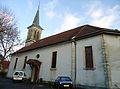
Saint-François de Sales church
Lutheran Church

Elementary school and music school


population
| Population development | |
|---|---|
| year | Residents |
| 1851 | 2228 |
| 1901 | 4526 |
| 1926 | 4259 |
| 1954 | 4170 |
| 1962 | 4570 |
| 1968 | 4924 |
| 1975 | 5521 |
| 1982 | 5682 |
| 1990 | 5569 |
| 1999 | 5348 |
With 5007 inhabitants (January 1, 2017) Beaucourt is one of the largest municipalities in the Territoire de Belfort. In the course of the 19th century, the population showed rapid growth in the course of industrialization. With almost 4600 inhabitants, the preliminary high was reached around 1900. This was followed by a period of stagnation and after 1930 a decline of 16%. In the period from 1955 to 1975 in particular, there was again significant growth (33%). With around 5700 inhabitants, the previous high was reached at the beginning of the 1980s. Since then, the population has decreased slightly again. By 1999, Beaucourt had lost a little over 300 people, a decrease of 6%. Today, the settlement area of Beaucourt has almost completely merged with those of Dasle and Dampierre-les-Bois.
Economy and Infrastructure
At the end of the 18th century, Beaucourt was developing into an industrial location. The industrial and commercial areas are concentrated on the valley basin north of the town center and on the plateau to the west of it. The most important employer in the area is Alsthom-Unelec, which produces electric motors and employs around 300 people. In addition, there are numerous smaller companies in the fields of micromechanics, metal processing, production of vehicle accessories, electronics industry and surface treatment. There are also various companies that are active in the service sector, a supermarket and numerous other retail shops for daily needs. Beaucourt is the location of a college. The Georges Brassens foyer serves as the cultural center. Thanks to the attractive residential area, Beaucourt also developed into a residential community for the Montbéliard agglomeration.
The village is well developed in terms of traffic. It is located on the D126 departmental road from Audincourt to Delle . The closest connection to the A36 motorway is around eleven kilometers away. Other road connections exist with Dampierre-les-Bois, Saint-Dizier-l'Évêque and Montbouton. Beaucourt is connected to Audincourt and the city of Montbéliard by a bus line.
literature
- Le Patrimoine des Communes du Territoire de Belfort. Flohic Editions, Paris 1999, ISBN 2-84234-037-X , pp. 23-29.
Web links
- Official website of the municipality of Beaucourt (French)
- More information about Beaucourt (French)
Individual evidence
- ↑ a b Cf. “Beaucourt: le temple luthérien” , in: Les temples ou églises luthériennes de France , accessed on January 24, 2016.