Suarce
| Suarce | ||
|---|---|---|

|
|
|
| region | Bourgogne-Franche-Comté | |
| Department | Territoire de Belfort | |
| Arrondissement | Belfort | |
| Canton | Grandvillars | |
| Community association | South Territoire | |
| Coordinates | 47 ° 34 ' N , 7 ° 5' E | |
| height | 370-407 m | |
| surface | 11.81 km 2 | |
| Residents | 436 (January 1, 2017) | |
| Population density | 37 inhabitants / km 2 | |
| Post Code | 90100 | |
| INSEE code | 90095 | |
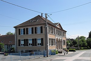
 Town hall and school in Suarce |
||
Suarce (German earlier Schwerz ) is a French commune in the department Territoire de Belfort in the region Bourgogne Franche-Comté .
geography
Suarce is located at 380 m above sea level, nine kilometers northeast of Delle and about 18 kilometers east-southeast of the city of Belfort (as the crow flies). The village extends in the plains of the Burgundian Gate , in a wide hollow on both sides of the Suarcine stream .
The area of the 11.81 km² large municipal area includes a section of the gently undulating landscape in the area of the Burgundian Gate (Trouée de Belfort). The central part of the area is crossed in a south-east-north-west direction by the Suarcine basin, which provides drainage to the Allaine . This hollow is flanked on both sides by a plateau that is an average of 390 m. It is mostly covered with arable and meadow land, but also shows some larger forest areas. The forest area of the Banbois extends to the west of the village . At 407 m, the highest point in Suarce is reached on the southern border of the municipality. In hollows and valleys there are numerous ponds that were created for fish farming. To the east, the community area extends over the plateau to the Lutter stream (right tributary of the Suarcine) and to the edge of the Oberwald forest .
Neighboring communities of Suarce are Chavanatte and Altenach in the north, Saint-Ulrich , Strueth and Hindlingen in the east, Lepuix-Neuf and Courtelevant in the south and Florimont in the southwest.
history
Suarce was first mentioned in writing in 823 under the name of Suerza in a document in which King Louis the Pious recorded the possessions of the Masevaux monastery . At that time there was already a church in Suarce. In the first half of the 14th century the village came under the sovereignty of the Habsburgs. It was part of the Florimont reign. Together with the Sundgau , Suarce came to the French crown with the Peace of Westphalia in 1648. Since 1793 the village has belonged to the Haut-Rhin department , but in 1871 it remained as part of the Territoire de Belfort, unlike the rest of Alsace, in France.
The village was connected to the French rail network in 1913 by a railway line from Belfort to Réchésy . However, operations were discontinued in 1948. In November 1944, fierce fighting between the Allies and German troops took place in the area of and Suarce, Lepuix-Neuf and Réchésy, during which the church and various houses were destroyed.
Attractions
The modern concrete building of the Notre-Dame de l'Assomption church in the form of a cylinder with a free-standing bell tower was inaugurated in 1971 after a wooden chapel had served as a place of worship since the Second World War. The oldest wayside cross in Suarce dates from 1776. In the old town center, various half-timbered houses in the traditional Sundgau style have been preserved. Also worth seeing is the memorial of the soldiers who died in the First and Second World Wars.
See also: List of Monuments historiques in Suarce
- Notre-Dame de l'Assomption church
population
| Population development | |
|---|---|
| year | Residents |
| 1962 | 320 |
| 1968 | 273 |
| 1975 | 284 |
| 1982 | 294 |
| 1990 | 339 |
| 1999 | 375 |
With 436 inhabitants (January 1, 2017), Suarce is one of the small communities in the Territoire de Belfort department. After the population had decreased significantly in the first half of the 20th century (in 1891 there were still 529 people), the population has continued to grow steadily since the early 1980s.
Economy and Infrastructure
Until well into the 20th century, Suarce was mainly a village characterized by agriculture (arable farming, fruit growing and cattle breeding), fish farming and forestry. In addition, there are now some local small businesses. In the meantime the village has turned into a residential community. Many workers are therefore commuters who go to work in the larger towns in the area and in the Belfort agglomeration.
The village is located off the major road connections on a department road that leads from Delle to Dannemarie . Further road connections exist with Vellescot, Chavanatte, Strueth and Lepuix-Neuf.
literature
- Le Patrimoine des Communes du Territoire de Belfort. Flohic Editions, Paris 1999, ISBN 2-84234-037-X , pp. 213-214.


