
Rougegoutte
| Rougegoutte | ||
|---|---|---|
.svg)
|
|
|
| region | Bourgogne-Franche-Comté | |
| Department | Territoire de Belfort | |
| Arrondissement | Belfort | |
| Canton | Giromagny | |
| Community association | Vosges du Sud | |
| Coordinates | 47 ° 44 ' N , 6 ° 51' E | |
| height | 426-910 m | |
| surface | 8.07 km 2 | |
| Residents | 976 (January 1, 2017) | |
| Population density | 121 inhabitants / km 2 | |
| Post Code | 90200 | |
| INSEE code | 90088 | |
 Mairie Rougegoutte |
||

Rougegoutte is a French commune in the department Territoire de Belfort in the region Bourgogne Franche-Comté .
geography
Rougegoutte is 451 m above sea level, two kilometers southeast of Giromagny and about eleven kilometers north of the city of Belfort (as the crow flies). The village extends at the southern foot of the Vosges , on the edge of the Giromagny basin, which extends between the Vosges, the hills of the Forêt de Roppe and the Montagne de Salbert, at the confluence of the village stream into the Rosemontoise . It is located in the Ballons des Vosges Regional Nature Park .
The area of the 8.07 km² large municipality covers a section in the area of the Vosges foothills. The southern part of the area is occupied by the plateau at the foot of the Vosges, which is an average of 450 m. It consists partly of arable land and meadow, partly of forest. The area is drained by the Rosemontoise, which flows south parallel to the Savoureuse and only flows into it north of Belfort. There are several ponds on the plateau that were once created for fish farming. In the far south, the municipal ban extends into the forest area of the Forêt de Vaivre .
To the northeast, the community area extends into the valley basin and the headwaters of the village stream. Thickly forested slopes rise to the heights of the Fayé and the Pointe des Roches in the southern Vosges. The highest point of Rougegoutte is reached here at 910 m. These heights belong to the chain of hills of the Baerenkopf, which extends to the south .
Rougegoutte includes the hamlet of Le Bringard (551 m) on the lower south-western slope of the Pointe des Roches and a few individual farms. Neighboring municipalities of Rougegoutte are Vescemont in the north, Grosmagny in the east, Chaux in the south and Giromagny in the west.
history
The village was first mentioned in writing in 1196, when Pope Celestine III. confirmed the possession of the church of Rougegoutte to the Saint-Maimboeuf chapter in Montbéliard. The parish of Rougegoutte included most of the localities in the Giromagny basin. Initially under the influence of the Counts of Montbéliard , the village came under the sovereignty of the Habsburgs in the mid-14th century. It was then part of the Rosemont dominion. Together with the Sundgau , Rougegoutte came to the French crown with the Peace of Westphalia in 1648. Since 1793 it belonged to the Haut-Rhin department , but in 1871 it remained as part of the Territoire de Belfort, unlike the rest of Alsace, in France. Today Rougegoutte is a member of the eight communes community association Communauté de communes la Haute Savoureuse .
Attractions
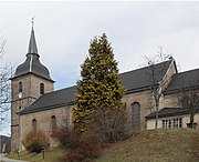
The Saint-Georges church was rebuilt in 1724 on a slightly elevated position on the edge of the plain and has a rich interior (see: List of Monuments historiques in Rougegoutte ).
Numerous traditional-style houses from the 17th and 18th centuries have been preserved in the old village center. There is a 400 year old linden tree in the village square.
- Saint-Georges church


population
| Population development | |
|---|---|
| year | Residents |
| 1962 | 789 |
| 1968 | 826 |
| 1975 | 892 |
| 1982 | 919 |
| 1990 | 858 |
| 1999 | 894 |
With 976 inhabitants (January 1, 2017), Rougegoutte is one of the smaller municipalities in the Territoire de Belfort department. After the population had decreased significantly in the first half of the 20th century (1450 people were still counted in 1896), slight population growth has been recorded since the beginning of the 1990s. The settlement area of Rougegoutte has now merged with those of Giromagny and Vescemont.
Economy and Infrastructure
For a long time, Rougegoutte was primarily a village characterized by agriculture (arable farming, fruit growing and cattle breeding) and forestry. In the course of the 19th and 20th centuries, various industrial companies settled here. The most important employer is a company of the Visteon Group, which manufactures cockpit systems for cars and supplies the automobile manufacturers Peugeot-Citroën and Daimler-Chrysler. There are also companies in the plastics industry, precision mechanics and local small businesses. In the meantime, the village has also turned into a residential community. Many workers are therefore commuters who go to work in the larger towns in the area and in the Belfort agglomeration.
The village is well developed in terms of traffic. It is located on a departmental road that leads from Giromagny along the Vosges foot to Étueffont . The closest connection to the A36 motorway is around 14 kilometers away. There are other road connections with Chaux and Vescemont.
literature
- Le Patrimoine des Communes du Territoire de Belfort. Flohic Editions, Paris 1999, ISBN 2-84234-037-X , pp. 182-183.