
Vézelois
| Vézelois | ||
|---|---|---|

|
|
|
| region | Bourgogne-Franche-Comté | |
| Department | Territoire de Belfort | |
| Arrondissement | Belfort | |
| Canton | Châtenois-les-Forges | |
| Community association | Grand Belfort | |
| Coordinates | 47 ° 36 ' N , 6 ° 55' E | |
| height | 350-412 m | |
| surface | 9.43 km 2 | |
| Residents | 953 (January 1, 2017) | |
| Population density | 101 inhabitants / km 2 | |
| Post Code | 90400 | |
| INSEE code | 90104 | |
 Mairie Vézelois |
||

Vézelois (German earlier Meadow Forest ) is a French commune in the department Territoire de Belfort in the region Bourgogne Franche-Comté .
geography
Vézelois is located at 366 m above sea level, about five kilometers southeast of the city of Belfort (as the crow flies). The former street-line village extends in the plains of the Burgundian Gate , on the plateau between the Grands Bois in the east and the Bosmont in the west, on the Praille.
The area of the 9.43 km² municipal area comprises a section of the landscape in the area of the Burgundian Gate (Trouée de Belfort) with only weak relief. The central part of the area is taken up by the wide area of Vézelois, which is drained by the Praille to the southeast to the Bourbeuse and thus to the Allaine . The plateau lies at an average of 370 m and is mostly covered with arable and meadow land, but also shows some larger forest areas. To the east, Vézelois shares in the vast forest of the Grands Bois . To the west, the municipality extends into the Bois de la Brosse on the heights of the Bosmont , on which the highest elevation of Vézelois is reached at 412 m. The northern boundary runs along the Neuf Fontaines stream . Here, as in the valley of the Praille, there are several ponds that were created for fish farming.
Neighboring municipalities of Vézelois are Pérouse and Chèvremont in the north, Fontenelle and Novillard in the east, Meroux in the south and Danjoutin in the west.
history
Vézelois is first mentioned in 1185 under the Latinized name Vesiliaco . Initially under the influence of the lords of Montbéliard, the village came under the sovereignty of the Habsburgs in the mid-14th century. It was then assigned to the dominion of Rosenfels (Rosemont). Vézelois was badly affected by Swedish troops in 1632 during the Thirty Years' War . Together with the Sundgau , the village came to the French crown with the Peace of Westphalia in 1648.
Since 1793 Vézelois has belonged to the Haut-Rhin department , but in 1871 it remained as part of the Territoire de Belfort, unlike the rest of Alsace, in France. From 1883 to 1886 the Fort of Vézelois (also Fort Ordener) was built, which formed part of the fortification ring around Belfort. Vézelois was connected to the French railway network in 1913 when the narrow-gauge railway from Belfort to Réchésy opened. However, as a result of competition from a bus line, operations were stopped again in 1938. Since 1998, Vézelois was initially part of the Communauté d'Agglomération Belfortaine , which was merged into the Communauté d'agglomération Grand Belfort in 2017 .
Attractions
The Saint-Thiébaud church was built from 1853 to 1877 in the neo-Gothic style. In the former train station of Vézelois (built in 1913) is now the Mairie (town hall). Fort Ordener, which covers a total of 20 hectares and served as an ammunition depot until 1994, is now a meeting place for various festivities.
See also: List of the Monuments historiques in Vézelois
- Saint-Thiébaud church in Vézelois

North side
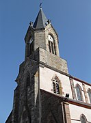
tower


population
| Population development | |
|---|---|
| year | Residents |
| 1962 | 373 |
| 1968 | 461 |
| 1975 | 588 |
| 1982 | 671 |
| 1990 | 664 |
| 1999 | 705 |
With 953 inhabitants (January 1, 2017), Vézelois is one of the small communes of the Territoire de Belfort department. After the population had decreased in the first half of the 20th century (625 people were still counted in 1906), there has been significant population growth since the beginning of the 1960s. Since then the number of inhabitants has doubled.
Economy and Infrastructure
Until well into the 20th century, Vézelois was primarily a village characterized by agriculture (arable farming, fruit growing and cattle breeding) and forestry. In addition, there are now various local small businesses. In the meantime the village has turned into a residential community. Many workers are therefore commuters who do their work in the agglomerations of Belfort and Montbéliard .
The village is located off the major thoroughfares on a departmental road that leads from Belfort to Suarce . The closest connection to the A36 motorway is around five kilometers away. There are other road connections with Chèvremont, Novillard and Meroux. Vézelois is connected to the city of Belfort by a bus line.
literature
- Le Patrimoine des Communes du Territoire de Belfort. Flohic Editions, Paris 1999, ISBN 2-84234-037-X , pp. 122-123.