
Trévenans
| Trévenans | ||
|---|---|---|
.svg)
|
|
|
| region | Bourgogne-Franche-Comté | |
| Department | Territoire de Belfort | |
| Arrondissement | Belfort | |
| Canton | Châtenois-les-Forges | |
| Community association | Grand Belfort | |
| Coordinates | 47 ° 34 ' N , 6 ° 52' E | |
| height | 327-422 m | |
| surface | 5.96 km 2 | |
| Residents | 1,248 (January 1, 2017) | |
| Population density | 209 inhabitants / km 2 | |
| Post Code | 90400 | |
| INSEE code | 90097 | |

Trévenans is a commune in the department Territoire de Belfort in the region Bourgogne Franche-Comté . The municipality was created in 1972 with the merger of the previously independent municipalities Trétudans (German formerly Trosteldingen or Troscholdingen ) and Vourvenans .
geography
Trévenans is located 336 m above sea level, about halfway between the cities of Belfort and Montbéliard , eight kilometers south of Belfort (as the crow flies). The village extends in the northern section of the basin of Montbéliard, on the eastern edge of the broad valley plain of the Savoureuse opposite Châtenois-les-Forges, at the western foot of the heights of the Bois du Fahy.
The area of the municipal area of 5.96 km² includes a section of the gently undulating landscape in the area of the Burgundian Gate (Trouée de Belfort). The western border mostly runs along the Savoureuse, which flows with several windings through an approximately one kilometer wide valley floor to the south and provides drainage to the Allan . The waterway of the Canal de la Haute-Saône , a branch of the Rhine-Rhône Canal, is also located in the valley floor . Various former sand and gravel pits on the valley floor have now been flooded.
From the course of the river, the municipality stretches eastward over the valley level, which is an average of 335 m, and the adjoining, gently rising slope to the peaks of the Bois du Fahy and the Bois Gros Jean . The hills are subdivided by the valleys of several short side streams of the Savoureuse. At 422 m, the Bois du Fahy is the highest point in Trévenans. A portion of the parish land east of the village belongs to the Fougerais arsenal.
The municipality of Trévenans consists of the two villages Trétudans (336 m) and Vourvenans (336 m), both located on the eastern edge of the Savoureuse valley. Neighboring municipalities of Trévenans are Sevenans and Moval in the north, Bourogne in the east, Dambenois and Nommay in the south and Châtenois-les-Forges and Bermont in the west.
history
Trétudans was first mentioned in 1147 under the name Trestudens . It had a chapel owned by the Lanthenans Priory . At the same time as Trétudans, Vourvenans was also called under the name Valvenans . Initially under the influence of the lords of Montbéliard, the two villages came under the sovereignty of the Habsburgs in the mid-14th century. Trétudans formed the center of its own rule. Together with the Sundgau , Trétudans and Vourvenans came to the French crown with the Peace of Westphalia in 1648.
Since 1793 the villages belonged to the Haut-Rhin department , but in 1871 they remained as part of the Territoire de Belfort, unlike the rest of Alsace, in France. With the opening of the tram from Montbéliard to Belfort, Trétudans was connected to the public transport network in 1913. However, operations on the line were given up again in 1940. With effect from January 1, 1972, Trétudans and Vourvenans merged to form the new municipality with the art name Trévenans. Since 2005, Trévenans was initially part of the Communauté d'Agglomération Belfortaine , which was merged into the Communauté d'agglomération Grand Belfort in 2017 .
Attractions
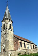
The Sainte-Marguerite church in Trétudans was rebuilt in 1852 on the site of the former mansion and was last extensively restored in 1997. In Vourvenans, some farmhouses in the traditional Franche-Comté style have been preserved.
See also: List of Monuments historiques in Trévenans
- St. Margaret's Church in Trévenans

South side
Southwest side


population
| year | 1962 | 1968 | 1975 | 1982 | 1990 | 1999 | 2006 |
| Residents | 675 | 688 | 835 | 1078 | 1108 | 1038 | 993 |
With 1248 inhabitants (January 1, 2017) Trévenans is one of the smaller municipalities in the Territoire de Belfort. After the population in the first half of the 20th century had always been in the range between 480 and 550 people, a significant increase in population was recorded from 1970 to 1980. With around 1100 inhabitants, the previous high was reached around 1990. Since then, the number of inhabitants has decreased slightly. Today the settlement area of Trévenans has almost completely merged with that of Châtenois-les-Forges.
Economy and Infrastructure

Until well into the 20th century, Trévenans was predominantly a village characterized by agriculture (arable farming, fruit growing and cattle breeding). An industrial and commercial zone has developed in the valley near Trétudans since the 1970s. Companies in the construction industry and service businesses have settled here. There are also various small businesses in the old town center. Many workers are also commuters who work in the agglomerations of Belfort and Montbéliard.
The village is well developed in terms of traffic. It is on the main road from Belfort to Montbéliard. The nearest connection to the A36 motorway , which crosses the municipality, is about two kilometers away. Trévenans is connected to the cities of Belfort and Montbéliard by a bus route. The Viaduc de la Savoureuse on the eastern section of the LGV Rhin-Rhône high-speed line, which was completed in autumn 2011, spans the Savoureuse , the Canal de la Haute-Saône and the Autoroute A 36 in northern Trévenan .
literature
- Le Patrimoine des Communes du Territoire de Belfort. Flohic Editions, Paris 1999, ISBN 2-84234-037-X , pp. 106-107.