Froidefontaine
| Froidefontaine | ||
|---|---|---|

|
|
|
| region | Bourgogne-Franche-Comté | |
| Department | Territoire de Belfort | |
| Arrondissement | Belfort | |
| Canton | Grandvillars | |
| Community association | South Territoire | |
| Coordinates | 47 ° 34 ' N , 6 ° 57' E | |
| height | 330-388 m | |
| surface | 4.55 km 2 | |
| Residents | 456 (January 1, 2017) | |
| Population density | 100 inhabitants / km 2 | |
| Post Code | 90140 | |
| INSEE code | 90051 | |
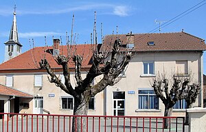
 Froidefontaine school and town hall |
||
Froidefontaine (German earlier Kaltenbrunn ) is a commune in the department Territoire de Belfort in the region Bourgogne Franche-Comté .
geography
Froidefontaine is 335 m above sea level, about ten kilometers southeast of the city of Belfort (as the crow flies). The village extends in the plains of the Burgundian Gate , on the southern edge of the wide valley of the Bourbeuse , opposite Charmois, between the plateaus of Les Grands Bois in the northwest and Bois Lachat in the southeast.
The area of the municipal area of 4.55 km² covers a section of the landscape in the area of the Burgundian Gate (Trouée de Belfort) with only weak relief. The northern border mostly runs along the Bourbeuse, which meanders through a wide valley floor and provides drainage to the Allaine . In the valley, which is more than a kilometer wide, there is also the waterway of the Rhine-Rhône Canal , which at Froidefontaine overcomes the height difference with a lock. From the Bourbeuse, the community area extends southeast over the valley floodplain and a gently rising slope, which is divided by several short side streams, to the adjacent plateau. This is an average of 375 m and is covered with arable and meadow land. In the far south and south-east is the Bois Lachat forest area , in which the highest elevation of Froidefontaine is reached at 388 m. In the basins and valleys there are various ponds that were created for fish farming.
Neighboring municipalities of Froidefontaine are Charmois , Autrechêne and Brebotte in the north, Recouvrance and Grosne in the east, Grandvillars and Morvillars in the south and Bourogne in the west.
history
Froidefontaine is first mentioned in writing in 1105, when Ermentrude, the widow of Count Thierry I of Montbéliard-Ferrette , left lands on the Bourbeuse to Cluny Abbey so that they could establish a priory here. The Froidefontaine Priory soon became an important spiritual center in the region. In the middle of the 14th century, Froidefontaine came under the sovereignty of the Habsburgs. In 1621 the priory came into the possession of the Jesuits of Ensisheim . It was destroyed in 1632 in the course of the Thirty Years War , but then rebuilt. Together with the Sundgau , Froidefontaine came to the French crown with the Peace of Westphalia in 1648. The priory came into the possession of the royal college in Colmar in 1756 and was secularized during the French Revolution , with the buildings becoming state property. Since 1793 Fontainefroide belonged to the department of Haut-Rhin , but remained in 1871 as part of the Territoire de Belfort in contrast to the rest of Alsace with France.
Attractions
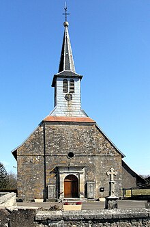
The Saint-Pierre church originally dates back to the Romanesque priory church of the early 12th century (parts of the apse from this period have been preserved), but has been redesigned several times over the years, the last time on a larger scale in the 18th century. A former priory building now houses the rectory. There is a neo-Gothic cross in the cemetery .
See also: List of Monuments historiques in Froidefontaine
population
| Population development | |
|---|---|
| year | Residents |
| 1962 | 399 |
| 1968 | 408 |
| 1975 | 431 |
| 1982 | 431 |
| 1990 | 437 |
| 1999 | 444 |
| 2007 | 462 |
With 456 inhabitants (January 1, 2017), Froidefontaine is one of the small communities in the Territoire de Belfort department. After the population in the first half of the 20th century had always been in the range between 330 and 390 people, a slight population growth has been recorded since then.
Economy and Infrastructure
Until well into the 20th century, Froidefontaine was primarily a village characterized by agriculture (arable farming, fruit growing and cattle breeding), fish farming and forestry. In addition, there are now a few small and medium-sized businesses, including a chemical factory and a mechanical workshop. The formerly important brick factory on the outskirts was closed. In the meantime, the village has also turned into a residential community. Many workers are therefore commuters who work in the larger towns in the area and in the agglomerations of Belfort and Montbéliard .
The village is well developed in terms of traffic. It is located near the main road N19, which leads from Belfort to Delle . The closest connection to the A36 motorway is around nine kilometers away. Further road connections exist with Brebotte, Charmois and Grandvillars.
literature
- Le Patrimoine des Communes du Territoire de Belfort. Flohic Editions, Paris 1999, ISBN 2-84234-037-X , pp. 197-200.


