
Novillard
| Novillard | ||
|---|---|---|
.svg)
|
|
|
| region | Bourgogne-Franche-Comté | |
| Department | Territoire de Belfort | |
| Arrondissement | Belfort | |
| Canton | Grandvillars | |
| Community association | Grand Belfort | |
| Coordinates | 47 ° 36 ' N , 6 ° 58' E | |
| height | 335-371 m | |
| surface | 3.79 km 2 | |
| Residents | 299 (January 1, 2017) | |
| Population density | 79 inhabitants / km 2 | |
| Post Code | 90340 | |
| INSEE code | 90074 | |
 Mairie |
||

Novillard (German earlier Neuweiler ) is a French commune in the department Territoire de Belfort in the region Bourgogne Franche-Comté .
geography
Novillard is 350 m above sea level, about nine kilometers east-southeast of the city of Belfort (as the crow flies). The village extends in the plain of the Burgundian Gate , on the plateau of Les Grands Bois, north of the wide valley of the Bourbeuse and west of the valley of the Madeleine .
The area of the 3.79 km² municipal area includes a section of the landscape in the area of the Burgundian Gate (Trouée de Belfort) with only weak relief. The eastern border mostly runs along the Madeleine, which meanders through an approximately 400 m wide valley floor and provides drainage over the Bourbeuse to the Allaine . The community area extends from the river to the west to the adjacent plateau, which averages 360 m. It is partly covered with arable and meadow land, partly with forest. To the west, the communal soil extends into the extensive forest area of the Grands Bois and the boggy valley of the Praille stream (right tributary of the Bourbeuse). In the Grands Bois, the highest point of Novillard is reached at 371 m.
Neighboring communities of Novillard are Fontenelle and Petit-Croix in the north, Montreux-Château in the east, Autrechêne and Charmois in the south and Meroux and Vézelois in the west.
history
Novillard is first mentioned in writing in 1251 in a document from the Froidefontaine Priory under the name Nueviller . The village has belonged to the Rougemont estate since it was first mentioned. In the middle of the 14th century it came under the sovereignty of the Habsburgs. Together with the Sundgau , Novillard came to the French crown with the Peace of Westphalia in 1648. Since 1793 the village has belonged to the Haut-Rhin department , but in 1871 it remained as part of the Territoire de Belfort, unlike the rest of Alsace, in France.
Attractions
The church of St-Julien-St-Vincent was rebuilt in 1770. In the center there are half-timbered houses from the 17th to 19th centuries in the traditional Sundgau style.
See also: List of the Monuments historiques in Novillard
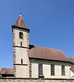
St-Julien-St-Vincent Church

Fallen memorial


population
| year | 1962 | 1968 | 1975 | 1982 | 1990 | 1999 | 2007 | 2016 |
| Residents | 103 | 83 | 89 | 181 | 196 | 205 | 245 | 298 |
With 299 inhabitants (January 1, 2017) Novillard is one of the small communities in the Territoire de Belfort department. After the population had decreased in the first half of the 20th century (170 people were still counted in 1911), there has been a significant increase in population since the mid-1970s.
Economy and Infrastructure
Until well into the 20th century, Novillard was mainly a village characterized by agriculture (arable farming, fruit growing and cattle breeding) and forestry. In addition, there are now some local small businesses. In the meantime the village has turned into a residential community. Many workers are therefore commuters who go to work in the larger towns in the area and in the Belfort agglomeration.
The village is located away from the major road connections on a departmental road that leads from Foussemagne to Autrechêne. The closest connection to the A36 motorway is around ten kilometers away. Another road connection is with Fontenelle.