Joncherey
| Joncherey | ||
|---|---|---|

|
|
|
| region | Bourgogne-Franche-Comté | |
| Department | Territoire de Belfort | |
| Arrondissement | Belfort | |
| Canton | Dent | |
| Community association | South Territoire | |
| Coordinates | 47 ° 32 ' N , 7 ° 0' E | |
| height | 349-401 m | |
| surface | 5.18 km 2 | |
| Residents | 1,353 (January 1, 2017) | |
| Population density | 261 inhabitants / km 2 | |
| Post Code | 90100 | |
| INSEE code | 90056 | |
| Website | http://www.joncherey.fr/ | |
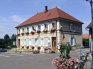
 town hall |
||
Joncherey (German earlier Guntscherach ) is a French commune in the department Territoire de Belfort in the region Bourgogne Franche-Comté .
geography
Joncherey is located at 357 m above sea level, two kilometers north of Delle and about 16 kilometers southeast of the city of Belfort (as the crow flies). The village extends on the eastern edge of the Allaine valley , in the plains of the Burgundian Gate , near the border with Switzerland .
The area of the 5.18 km² municipal area includes a section of the gently undulating landscape in the area of the Burgundian Gate (Trouée de Belfort). The area is limited in the west by the Allaine, which flows here with numerous windings through an approximately 1 km wide valley floor (355 m) to the northwest. The southern border runs along the Coeuvatte , which flows into the Allaine near the village. From the course of the river, the community area extends northeast over the flat floodplain and the subsequent gently rising slope of Joncherey to the plateau of the Burgundian Gate, which is an average of 390 m. It is partly covered with arable land and meadow, partly with forest and is divided by two valleys that open towards the Allaine. In hollows and valleys in the area of the Bois du Procès and the Bois du Magny there are several ponds that were created for fish farming. At 401 m, the highest point in Joncherey is reached in the Bois du Procès.
The village of Les Roselets (370 m) on the northern outskirts belongs to Joncherey . Neighboring communities of Joncherey are Grandvillars and Boron in the north, Faverois in the east, Delle in the south and Thiancourt in the west.
history
The area around Delle came to the Murbach Monastery in 728 through a gift from Count Eberhard von Alsace . Joncherey is first mentioned in 1290 under the name Juncherye . In the period that followed, a distinction was made between Grand-Joncherey and Petit-Joncherey . In the first half of the 14th century, the village came under the sovereignty of the Habsburgs and belonged to the lordship of Delle. Together with the Sundgau , it came to the French crown with the Peace of Westphalia in 1648.
Since 1793 Joncherey belonged to the department of Haut-Rhin , but remained in 1871 as part of the Territoire de Belfort in contrast to the rest of Alsace with France. The reason for this was the division of the region in 1871 largely along the German-French language border. Jonchery was French-speaking and therefore stayed with France. On August 2, 1914, the corporal Jules-André Peugeot was killed in Joncherey by a German soldier of the Jäger Regiment on Horseback No. 5 , who was stationed in Mulhouse , Germany at that time . Peugeot is considered the first deaths of the French armed forces in the First World War . Lieutenant Albert Mayer , who is believed to be the first German dead in the war, fell in the same skirmish .
Together with Lebetain , Joncherey was merged with Delle in 1972, but got its independence back in 1982.
Attractions
The village church of Joncherey was built in the middle of the 19th century. Other sights include the 19th-century Sainte-Véronique Chapel and the memorial to Corporal Jules-André Peugeot .
See also: List of Monuments historiques in Joncherey
population
| Population development | |
|---|---|
| year | Residents |
| 1962 | 783 |
| 1968 | 981 |
| 1975 | 1100 |
| 1982 | 1263 |
| 1990 | 1300 |
| 1999 | 1314 |
With 1353 inhabitants (January 1, 2017) Joncherey is one of the smaller municipalities in the Territoire de Belfort. After the population in the first half of the 20th century had always been in the range between 410 and 520 people, a significant increase in population was recorded, especially from 1950 to 1990. Since then, the number of inhabitants has remained at an almost constant level.
Economy and Infrastructure
Until well into the 20th century, Joncherey was a village dominated by agriculture (arable farming, fruit growing and cattle breeding), fish farming and forestry. In addition, there are now various local small businesses. In the meantime the village has turned into a residential community. Many employed people are therefore commuters who work in Delle and in the agglomerations of Belfort and Montbéliard .
The village is well developed in terms of traffic. It is on the main road from Belfort to Delle. With the opening of the N19 expressway, which is to connect the A36 motorway with the Swiss A16 under construction , Joncherey was relieved of through traffic. The Belfort – Delle railway runs through the municipality and was reactivated with a station in Joncherey following the timetable change on December 9, 2018.
literature
- Le Patrimoine des Communes du Territoire de Belfort. Flohic Editions, Paris 1999, ISBN 2-84234-037-X , pp. 139-140.


