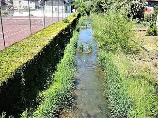
Coeuvatte
|
Coeuvatte (also Covatte in France) |
||
|
The Coeuvatte in Florimont |
||
| Data | ||
| Water code | CH : 3139, FR : U2330500 | |
| location | Switzerland , France | |
| River system | Rhône | |
| Drain over | Allaine → Doubs → Saône → Rhône → Mediterranean | |
| source | in the municipality of Coeuve, 47 ° 27 ′ 16 ″ N , 7 ° 5 ′ 59 ″ E |
|
| Source height | 430 m above sea level M. | |
| muzzle | at Joncherey in the Allaine coordinates: 47 ° 31 '28 " N , 6 ° 59' 55" E 47 ° 31 '28 " N , 6 ° 59' 55" E |
|
| Mouth height | approx. 354 m | |
| Height difference | approx. 76 m | |
| Bottom slope | approx. 4.8 ‰ | |
| length | 15.7 km | |
| Right tributaries | Vendline | |
The Coeuvatte , also known as Covatte in France , is an approximately 16 km long right tributary of the Allaine in the catchment area of the Rhône , in the Swiss canton of Jura and in the French department Territoire de Belfort ( Bourgogne-Franche-Comté region ). The river is named after its place of origin, the municipality of Coeuve in the Ajoie .
After the river one of the municipalities Coeuve should Damphreux and Lugnez to be formed fusion community La Coeuvatte be named. However, this project has failed.
geography
The headwaters of the Coeuvatte are located in the undulating landscape of the Table Jura in the Ajoie northeast of the town of Porrentruy in the municipality of Coeuve, at around 430 m above sea level. For the first 6 kilometers or so, the Coeuvatte flows northwards on Swiss soil through an initially wide, later gradually narrowing valley basin. It passes through the municipalities of Damphreux and Lugnez . Below Lugnez, it reaches the border with France . With a maximum 500 m wide valley, it crosses the forest heights of the Mont (in the east) and the Forêt de Florimont (in the west).
At Florimont the Coeuvatte steps out into the flat landscape of the Burgundian Gate between the Vosges and the Jura . Here it turns in a west-northwest direction and takes its most important tributary, the Vendline , from the right . It flows through a wide valley basin along the northernmost foothills of the Table Jura and only has a gradient of 0.5% here. At Joncherey , a few kilometers north of Delle , the Coeuvatte flows into the Allaine as a right tributary at an altitude of 354 m.
Hydrology
The Coeuvatte has a pluvial discharge regime with strongly fluctuating water levels. Floods mainly occur in the winter months and in spring when there is heavy rainfall in combination with snowmelt. Summer dry periods are responsible for very low water levels. The water power of the Coeuvatte was previously used to operate numerous mills. At Faverois, the river feeds a number of fish ponds.
Individual evidence
- ↑ Geoserver of the Swiss Federal Administration ( information )
- ↑ mouth height according to geoportail.gouv.fr
- ↑ Coeuvatte at SANDRE (French)
- ↑ cf. Official register of municipalities FSO
