
Florimont
| Florimont | ||
|---|---|---|
.svg)
|
|
|
| region | Bourgogne-Franche-Comté | |
| Department | Territoire de Belfort | |
| Arrondissement | Belfort | |
| Canton | Dent | |
| Community association | South Territoire | |
| Coordinates | 47 ° 31 ' N , 7 ° 4' E | |
| height | 367-505 m | |
| surface | 18.19 km 2 | |
| Residents | 446 (January 1, 2017) | |
| Population density | 25 inhabitants / km 2 | |
| Post Code | 90100 | |
| INSEE code | 90046 | |
 Florimont town hall and school building |
||

Florimont (German earlier Blumenberg ) is a French commune in the department Territoire de Belfort in the region Bourgogne Franche-Comté .
geography
Florimont is 384 m above sea level, five kilometers east of Delle and about 21 km southeast of the city of Belfort (as the crow flies). The village extends in the transition area between the plains of the Burgundian Gate and the northern foothills of the Jura , in the Coeuvatte valley at the northern foot of the heights of Florimont, near the border with Switzerland .
The area of the municipal area of 18.19 km² includes a section of the gently undulating landscape in the area of the Burgundian Gate (Trouée de Belfort). The southern part of the area is crossed in a southeast-northwest direction by the up to 500 m wide valley low of the Coeuvatte, which provides drainage to the Allaine . It takes on an important tributary north of the village with the Vendline . The valley is flanked in the south by the densely wooded heights of Florimont, on which the highest point in the municipality is reached at 505 m, and by the plateau of Saint-André. Between the Coeuvatte and Vendline valleys, Florimont contributes to the height of Les Ragies (454 m).
To the north, the community area extends in a long but narrow strip onto the wide plateau of the Burgundian Gate, which averages 400 m. It is partly covered with arable land and meadow, partly with forest (including the vast Grand Bois ). In hollows and valleys there are numerous ponds that were created for fish farming. This northern part of the municipality is drained by the Ruisseau de l'Écrevisse to the Bourbeuse .
Florimont includes the hamlet of Saint-André (418 m) on the plateau south of the Coeuvatte valley and various individual farms in the clearings north of the Grand Bois. Neighboring communities of Florimont are Vellescot , Chavannes-les-Grands and Chavanatte in the north, Suarce and Courtelevant in the east, Courcelles and the Swiss Boncourt in the south and Delle , Faverois and Boron in the west.
history
During the Roman period the important traffic route from Epomanduodurum ( Mandeure ) to Augusta Raurica crossed the municipality. The remains of a watchtower testify to this time. Florimont initially belonged to Alsace before it came to the Counts of Burgundy in 895. The village formed a fiefdom that the bishops of Basel left to the Counts of Ferrette in the 11th century. At that time a castle was built above Florimont. The village was also fortified and quickly gained in importance. The rule that belonged to the Blumenberg family also included the neighboring villages of Courcelles, Courtelevant, Réchésy, Lepuix-Neuf, Chavanatte, Suarce, Boron, Grosne and Faverois in the 13th century. In the first half of the 14th century the village came under the sovereignty of the Habsburgs. Since the 15th century, there has been a weekly market and two annual markets in Florimont.
The lords of Pfirt zu Florimont had been wealthy here since the 16th century . Florimont Castle was destroyed in a fire in 1583, but was subsequently rebuilt. During the Thirty Years War , the village and castle were looted and devastated by Swedish troops. Together with the Sundgau , Florimont came to the French crown with the Peace of Westphalia in 1648. After the death of his father-in-law Gaspard Nicolas de Barbaud de Florimont in 1783, the castle ruins, along with the rest of the property of Francois Nicolas de Salomon, also passed to the von Pfirt family.
Florimont has belonged to the Haut-Rhin department since 1793, but remained in France in 1871 as part of the Territoire de Belfort, unlike the rest of Alsace .
population
With 446 inhabitants (January 1, 2017), Florimont is one of the small municipalities of the Territoire de Belfort. After the population had decreased significantly in the first half of the 20th century (425 people were still counted in 1881), the population has continued to grow since the early 1960s.
| Population development | ||||||||
|---|---|---|---|---|---|---|---|---|
| year | 1962 | 1968 | 1975 | 1982 | 1990 | 1999 | 2009 | |
| Residents | 244 | 292 | 279 | 324 | 388 | 398 | 423 | |
Economy and Infrastructure
Until well into the 20th century, Florimont was primarily a village characterized by agriculture (arable farming, fruit growing and cattle breeding), fish farming and forestry. In addition, there are now various local small businesses. In the meantime the village has turned into a residential community. Many employed people are therefore commuters who work in Delle and in the agglomerations of Belfort and Montbéliard .
The village is well developed in terms of traffic. It is close to the D463 main road from Delle to Saint-Louis . The closest connection to the A36 motorway is around 20 kilometers away. Further road connections exist with Courtelevant and Courcelles.
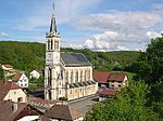
Parish Church of Florimont 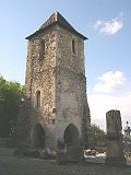
Former church tower


Attractions
In the middle of the village is the parish church Eglise de la Présentation de la Vierge , which was rebuilt in 1863 in the neo-Gothic style. It has rich furnishings (furniture from the 18th century) and replaced the old church, of which only the tower (in the cemetery) remains today.
The town center is characterized by various farmhouses in the traditional Alsatian style of the 18th century. On a ledge above Florimont there is a round castle tower, which was built after the French Revolution by Gustave Armand Henri, Comte de Reise, in memory of the former castle and bears the coat of arms of the Lords of Pfirt. Before that, the ruins of the former castle had passed through several hands and a. owned by Joseph Bruat of Grandvillars, the father of the future Admiral Armand Joseph Bruat .
literature
- Le Patrimoine des Communes du Territoire de Belfort. Flohic Editions, Paris 1999, ISBN 2-84234-037-X , pp. 137-139.
Individual evidence
- ↑ a b c Paul Stintzi: Blumenberg and Tattenried in: Alemannisches Institut Freiburg / Breisgau (Ed.): Alemannisches Jahrbuch 1964/65 , Konkordia, Bühl (Baden) 1966, p. 164 f, preview in the Google book search
- ↑ History summary on www.florimont.fr ( Memento of the original from January 6, 2014 in the Internet Archive ) Info: The archive link was inserted automatically and has not yet been checked. Please check the original and archive link according to the instructions and then remove this notice. (French)