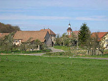
Banvillars
| Banvillars | ||
|---|---|---|

|
|
|
| region | Bourgogne-Franche-Comté | |
| Department | Territoire de Belfort | |
| Arrondissement | Belfort | |
| Canton | Châtenois-les-Forges | |
| Community association | Grand Belfort | |
| Coordinates | 47 ° 36 ' N , 6 ° 49' E | |
| height | 348-444 m | |
| surface | 4.67 km 2 | |
| Residents | 282 (January 1, 2017) | |
| Population density | 60 inhabitants / km 2 | |
| Post Code | 90800 | |
| INSEE code | 90007 | |
 Mairie |
||
Banvillars (German earlier Banweiler ) is a French commune in the department Territoire de Belfort in the region Bourgogne Franche-Comté .
geography
Banvillars is about six kilometers southwest of the city of Belfort . The village extends in the area of the Burgundian Gate (Trouée de Belfort), in a wide hollow west of the valley of the Savoureuse and its tributary river Douce, between the heights of Grand Bois in the south-east and Bois du Mont in the north-west.
The area of the 4.67 km² municipality covers a section of the gently undulating landscape in the area of the Burgundian Gate. The central part of the area is occupied by the Banvillars depression, which is 350 m on average and 1.5 km wide. It is used agriculturally as arable and meadow land. The village stream provides drainage to the northeast to the Douce (tributary of the Savoureuse). The valley of Banvillars is flanked by woody heights: in the north-west of the Bois du Mont , on which the highest point of Banvillars is reached at 444 m, in the south-west of the Beau Bois (415 m; with the Fort du Haut-Bois) and in the south from the Grand Bois (425 m). The Grand Bois area is part of the Bois d'Oye military area.
Neighboring municipalities of Banvillars are Urcerey and Argiésans in the north, Dorans in the east, Brevilliers in the southwest and Échenans in the west.
history
Various finds that were made when the railway line from Belfort to Montbéliard was built around 1850 indicate that the municipality of Banvillars was settled during the Gallo-Roman period. Banvillars was first mentioned in a document at the beginning of the 12th century. It formed the center of its own little rule. Initially under the influence of the lords of Montbéliard, Banvillars came under the sovereignty of the Habsburgs in the mid-14th century. In 1580 the fiefdom of Banvillars passed to the von Landenberg family. Together with the Sundgau , the village came to the French crown with the Peace of Westphalia in 1648. Since 1793 Banvillars has belonged to the Haut-Rhin department , but remained in France in 1871 after the Franco-Prussian War as part of the Territoire de Belfort, unlike the rest of Alsace . At the height of the Beau-Bois in the area of the remains of the medieval castle, the Fort du Haut-Bois was built from 1889, which was part of the fortification ring around Belfort.
Attractions

The church of Saint-Ambroise was rebuilt in the 19th century and has remarkable furnishings, including a wooden statue (19th century) of John the Baptist. The former rectory now houses the municipal administration (Mairie). Fort du Haut-Bois (1889) and the sparse remains of the medieval castle are located on the top of the forest southwest of the village.
population
| Population development | |
|---|---|
| year | Residents |
| 1962 | 132 |
| 1968 | 141 |
| 1975 | 203 |
| 1982 | 208 |
| 1990 | 237 |
| 1999 | 242 |
With 282 inhabitants (January 1, 2017), Banvillars is one of the small communities in the Territoire de Belfort department. After the population in the first half of the 20th century had always been in the range between 110 and 150 people, there has been significant population growth since the beginning of the 1970s.
Economy and Infrastructure
Until well into the 20th century, Banvillars was a village dominated by agriculture (arable farming, fruit growing and cattle breeding). In addition, there are now various local small businesses. In the meantime the village has turned into a residential community. Many workers are therefore commuters who work in the metropolitan areas of Belfort and Montbéliard .
The village is well developed in terms of traffic. It is on the main road from Belfort and Sevenans to Héricourt . The closest connection to the A36 motorway is around five kilometers away. Further road connections exist with Dorans and Argiésans.
literature
- Le Patrimoine des Communes du Territoire de Belfort. Flohic Editions, Paris 1999, ISBN 2-84234-037-X , p. 94.

