
Valdoie
| Valdoie | ||
|---|---|---|
.svg)
|
|
|
| region | Bourgogne-Franche-Comté | |
| Department | Territoire de Belfort | |
| Arrondissement | Belfort | |
| Canton | Valdoie (main town) | |
| Community association | Grand Belfort | |
| Coordinates | 47 ° 40 ′ N , 6 ° 51 ′ E | |
| height | 370-438 m | |
| surface | 4.66 km 2 | |
| Residents | 5,300 (January 1, 2017) | |
| Population density | 1,137 inhabitants / km 2 | |
| Post Code | 90300 | |
| INSEE code | 90099 | |
| Website | www.ville-de-valdoie.fr | |
 Mairie Valdoie |
||

Valdoie (German earlier Wedau ) is a French commune in the department Territoire de Belfort in the region Bourgogne Franche-Comté . It is the capital of the canton of Valdoie in the arrondissement of Belfort .
geography
Valdoie is located 377 m above sea level, about four kilometers north of the city of Belfort (as the crow flies). The largest agglomeration of Belfort extends in the foothills of the Vosges , on both sides of the Savoureuse , from the Giromagny basin through a narrow point between the hills of the Montagne de Salbert (in the west) and the Forêt de Roppe (in the east) into the Burgundian region Gate steps out.
The area of the 4.66 km² municipal area includes a section in the northern area of the Burgundian Gate (Trouée de Belfort). The central part of the area is occupied by the approximately one kilometer wide valley plain of the Savoureuse, which averages 370 m. It is crossed by the Savoureuse, which receives the Rosemontoise below the town center , from northwest to southeast. To the west, the parish reaches to the foot of the Montagne de Salbert, to the north into the plain of the Giromagny basin. In the east, the community area extends into the hilly, densely wooded landscape of the Forêt de Roppe and the Forêt d'Arsot. Here, at 438 m, Valdoie's highest point is reached. In a side valley of the Rosemontoise there are several ponds that were once created for fish farming.
Neighboring communities of Valdoie are Sermamagny and Éloie in the north, Offemont in the east and Belfort in the south and west.
history
Valdoie probably originated in the 11th century at a ford of the Savoureuse. The village's early names are Vaydoie , Waido , Val d'Oye and Valdoye . The place name is etymologically interpreted as vadum (Latin for ford ) and oye (Celtic for water , river ; Oye was the earlier name of the Savoureuse). Initially under the influence of the Counts of Montbéliard , Valdoie belonged to the Rosemont domain. This came under the sovereignty of the Habsburgs in the middle of the 14th century. Together with the Sundgau , the village came to the French crown with the Peace of Westphalia in 1648. Since 1793 Valdoie belonged to the department of Haut-Rhin , but remained in 1871 as part of the Territoire de Belfort, unlike the rest of Alsace, in France.
In the course of the 19th century the industrialization of the village on the northern edge of Belfort began. The metalworking industry (Page, since 1852) and the textile industry (Dollfus and Noack, 1898) were of particular importance. With the construction of the railway line from Belfort to Vesoul , Valdoie was connected to the French railway network. Since 1973, Valdoie was a member of the Belfort agglomeration, which in 1999 became the Communauté d'Agglomération Belfortaine , which in turn became part of the Communauté d'agglomération Grand Belfort in 2017 .
Attractions
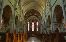
The current Saint-Joseph church was built at the beginning of the 20th century on the site of a church from 1780. Various buildings and factory areas from this period are reminiscent of the era of industrialization in the 19th century.
- Saint Joseph Church in Valdoie


population
| year | 1851 | 1901 | 1926 | 1962 | 1968 | 1975 | 1982 | 1990 | 1999 | 2007 |
| Residents | 428 | 2575 | 3266 | 3896 | 3983 | 4466 | 4572 | 4314 | 4843 | 5022 |
With 5300 inhabitants (January 1, 2017) Valdoie is one of the large municipalities of the Territoire de Belfort. The population of Valdoie grew in several spurts. Particularly high growth rates were recorded from 1871 to 1911, when the number of inhabitants increased sixfold. After a long period of stagnation in the first half of the 20th century, the number of inhabitants rose again significantly from 1950 to 1975. Another period of stagnation or a slight decline followed before a clear increase set in again in the 1990s. Today the settlement area of Valdoie has grown together almost seamlessly with those of Belfort and Offemont.
Economy and Infrastructure

Since the middle of the 19th century, Valdoie developed into an industrial community. Today, numerous small and medium-sized businesses are based in the community, with the metal processing industry, textile and chemical industry, electrical engineering, construction and printing being the most important branches. There is also a large supermarket and many other retail shops for daily needs. Many workers are also commuters who work in the other municipalities of the agglomerations of Belfort and Montbéliard . Valdoie is the location of an agricultural school.
The village is well developed in terms of traffic. It is on the main road from Belfort to Giromagny . The closest connection to the A36 motorway is around five kilometers away. Other road connections exist with Évette-Salbert, Éloie and Offemont. Valdoie is connected to Belfort by a bus line. The community had a train station on the Paris – Mulhouse line .
Community partnerships
Valdoie maintains partnership relationships with the communities of Blumberg in Baden-Württemberg and Vipalogho in Burkina Faso .
literature
- Le Patrimoine des Communes du Territoire de Belfort. Flohic Editions, Paris 1999, ISBN 2-84234-037-X , pp. 244–245.