Fontaine (Territoire de Belfort)
| Fontaine | ||
|---|---|---|

|
|
|
| region | Bourgogne-Franche-Comté | |
| Department | Territoire de Belfort | |
| Arrondissement | Belfort | |
| Canton | Grandvillars | |
| Community association | Grand Belfort | |
| Coordinates | 47 ° 40 ′ N , 7 ° 0 ′ E | |
| height | 347-378 m | |
| surface | 6.96 km 2 | |
| Residents | 603 (January 1, 2017) | |
| Population density | 87 inhabitants / km 2 | |
| Post Code | 90150 | |
| INSEE code | 90047 | |
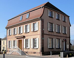
 Mairie Fontaine |
||
Fontaine (German earlier Brunn ) is a French commune in the department Territoire de Belfort in the region Bourgogne Franche-Comté . It belongs to the Arrondissement of Belfort .
geography
Fontaine is 363 m above sea level, about eleven kilometers east-northeast of the city of Belfort (as the crow flies). The former street-line village extends in the Burgundian Gate , on the plateau in the foothills of the Vosges , in the wide valley of the Ruisseau de Saint-Nicolas .
The area of the 6.96 km² municipal area comprises a section of the landscape in the area of the Burgundian Gate (Trouée de Belfort) with only weak relief. The central part of the area is crossed in a north-south direction by the valley level of the Ruisseau de Saint-Nicolas, which has a width of around two kilometers. The stream drains the area via the Bourbeuse to the Allaine . The level in the foothills of the Vosges is on average 360 m. It is mainly covered with arable and meadow land, but also shows some forest areas. To the east, the municipality extends to the Loutre stream. In the west, the community area extends into the Fahy forest . Here, at 378 m, Fontaine's highest elevation is reached.
Neighboring municipalities of Fontaine are Larivière and Vauthiermont in the north, Reppe and Chavannes-sur-l'Étang in the east, Foussemagne and Frais in the south and Phaffans and Lacollonge in the west.
history
The name Fontanis appears as early as the 12th century . However, only the mention of 1441 for today's village is considered certain. Initially under the influence of the lords of Montbéliard, Fontaine came under the sovereignty of the Habsburgs in the mid-14th century. It belonged to the lordship of Montreux , which was owned by the Reinach family from 1560. Together with the Sundgau , Fontaine came to the French crown with the Peace of Westphalia in 1648. Since 1793 the village has belonged to the Haut-Rhin department , but in 1871 it remained as part of the Territoire de Belfort, unlike the rest of Alsace, in France. Since 1997, Fontaine was initially part of the Communauté de communes du Tilleul , which was merged into the Communauté d'agglomération Grand Belfort in 2017 . Until 2015, Fontaine was the eponymous capital of the canton of Fontaine, which was dissolved that year .
Attractions
The Exaltation of the Cross ( l'Exaltation de la Sainte-Croix ) was rebuilt in 1788. In the village square is the Turenne linden tree, which is named after Marshal Turenne , who stayed here around the turn of the year 1674/75. It is believed to be more than 700 years old.
population
| Population development | |
|---|---|
| year | Residents |
| 1962 | 298 |
| 1968 | 291 |
| 1975 | 373 |
| 1982 | 353 |
| 1990 | 435 |
| 1999 | 524 |
With 603 inhabitants (January 1, 2017) Fontaine is one of the small municipalities of the Territoire de Belfort. After the population had decreased in the first half of the 20th century (401 people were still counted in 1886), a significant increase in population has been recorded since the beginning of the 1970s.
Economy and Infrastructure
Until well into the 20th century, Fontaine was a village dominated by agriculture (arable farming, fruit growing and cattle breeding) and forestry. It was the location of the Belfort-Fontaine airfield (opened in 1914), which was abandoned in 1986. A large industrial and commercial zone has been built on the site of the Aéroparc since 1992. Numerous companies in the transport industry, apparatus engineering, the automotive industry, logistics companies and distribution centers as well as the metal and plastics processing industry have settled here.
The village is well developed in terms of traffic. It is on the departmental road that leads from Montreux-Château to Lachapelle-sous-Rougemont . The closest connection to the A36 motorway is around four kilometers away. Further road connections exist with Lacollonge and Foussemagne.
literature
- Le Patrimoine des Communes du Territoire de Belfort. Flohic Editions, Paris 1999, ISBN 2-84234-037-X , p. 150.


