Auxelles skin
| Auxelles skin | ||
|---|---|---|

|
|
|
| region | Bourgogne-Franche-Comté | |
| Department | Territoire de Belfort | |
| Arrondissement | Belfort | |
| Canton | Giromagny | |
| Community association | Vosges du Sud | |
| Coordinates | 47 ° 45 ' N , 6 ° 46' E | |
| height | 510-1,140 m | |
| surface | 6.48 km 2 | |
| Residents | 289 (January 1, 2017) | |
| Population density | 45 inhabitants / km 2 | |
| Post Code | 90200 | |
| INSEE code | 90006 | |
 Town hall and school building |
||
Auxelles-Haut (German earlier upper Assel ) is a French commune in the department Territoire de Belfort in the region Bourgogne Franche-Comté .
geography
Auxelles-Haut is 552 m above sea level, about 14 kilometers north-northwest of the city of Belfort (as the crow flies). The village extends in the southern Vosges , in an elevated position on both sides of the Rhôme stream, on the edge of the Giromagny basin and at the southern foot of the Planche des Belles Filles . It is located in the Ballons des Vosges Regional Nature Park . Auxelles-Haut is the westernmost commune of the Territoire de Belfort department.
The area of the 6.48 km² municipal area includes a section in the area of the southern Vosges. The heavily reliefed and predominantly wooded area is located in the headwaters of the Rhôme . This ensures the drainage to the south to the Savoureuse . To the north of the village, the communal soil extends into the narrow valley with the source of the Rhôme. The valley is surrounded by steep, densely wooded slopes. Most of the municipal boundary runs on the surrounding mountain ranges: in the west the Mont Ménard (927 m), in the north the Planche des Belles Filles (on which the highest elevation of Auxelles-Haut is reached at 1140 m) and in the east the Mont Ordon-Verrier (967 m). These mountain ranges form the southern foothills of the Ballon d'Alsace .
Neighboring communities of Auxelles-Haut are Lepuix in the north, Giromagny in the east, Auxelles-Bas in the south and Plancher-Bas and Plancher-les-Mines in the west.
history
Auxelles was first mentioned in a document in the 14th century. The village was created by the immigration of miners from Saxony and Tyrol, who mined the lead and silver deposits here. Initially under the influence of the Counts of Montbéliard , the village came under the sovereignty of the Habsburgs in the mid-14th century. A distinction has been made between the two communities Auxelles-Haut and Auxelles-Bas since 1569. Together with the Sundgau , Auxelles-Haut came to the French crown with the Peace of Westphalia in 1648. At the end of the 18th century the exploitation of the mines stopped. Auxelles-Haut has belonged to the Haut-Rhin department since 1793, but in 1871 it remained part of the Territoire de Belfort, unlike the rest of Alsace, in France. Today Auxelles-Haut is a member of the eight municipalities community association Communauté de communes la Haute Savoureuse .
Attractions
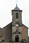
The Mariahilf Church ( Église Notre-Dame-Auxiliatrice ) was built from 1841.
- Mariahilf Church in Auxelles-Haut
population
| year | 1962 | 1968 | 1975 | 1982 | 1990 | 1999 | 2007 |
| Residents | 301 | 256 | 228 | 220 | 252 | 305 | 305 |
With 289 inhabitants (January 1, 2017), Auxelles-Haut is one of the small municipalities of the Territoire de Belfort. After the population had decreased markedly in the first half of the 20th century (1010 people were still counted in 1891), slight population growth has been recorded again since the beginning of the 1980s.
Economy and Infrastructure
Auxelles-Haut was early on a village dominated by trades (mills, weaving mills). Today there are some small and medium-sized businesses, including precision engineering. In the meantime, the village has also turned into a residential community. Many workers are therefore commuters who go to work in the larger towns in the area and in the Belfort agglomeration.
The village is away from the major thoroughfares. The main access is from Auxelles-Bas; Another road connection exists with Giromagny. The closest connection to the A36 motorway is around 16 kilometers away.
literature
- Le Patrimoine des Communes du Territoire de Belfort. Flohic Editions, Paris 1999, ISBN 2-84234-037-X , pp. 164-166.


