
Phaffans
| Phaffans | ||
|---|---|---|
|
||
| region | Bourgogne-Franche-Comté | |
| Department | Territoire de Belfort | |
| Arrondissement | Belfort | |
| Canton | Grandvillars | |
| Community association | Grand Belfort | |
| Coordinates | 47 ° 40 ′ N , 6 ° 56 ′ E | |
| height | 345-381 m | |
| surface | 3.24 km 2 | |
| Residents | 451 (January 1, 2017) | |
| Population density | 139 inhabitants / km 2 | |
| Post Code | 90150 | |
| INSEE code | 90080 | |
| Website | http://www.phaffans.com/ | |
 Mairie Phaffans |
||

Phaffans (German earlier Pfeffingen ) is a French commune in the department Territoire de Belfort in the region Bourgogne Franche-Comté .
geography
Phaffans is located at 363 m, about six kilometers east-northeast of the city of Belfort (as the crow flies). The village extends north of the Burgundian Gate , on the plateau south of the Forêt de Roppe in the foreland of the Vosges , east of the streams of Ermite and Autruche.
The area of the 3.24 km² municipal area comprises a section of the landscape in the area of the Burgundian Gate (Trouée de Belfort) with only weak relief. The main part of the area is occupied by a plateau, which is on average 360 m. It is mostly covered with arable and meadow land, but also shows some forest areas. The plateau is drained by the Ermite , which flows into the Autruche south of the village. This flows through a more than 500 m wide flood plain to the southeast and ensures drainage to the Bourbeuse and thus to the Allaine . To the east, the community area extends over the plateau, on which the highest elevation of Phaffans is reached at 381 m, in a narrow strip into the valley basin of the Madeleine and into the northern part of the extensive forest Bois de Bessoncourt .
Neighboring communities of Phaffans are Eguenigue , Menoncourt and Lacollonge in the north, Fontaine in the east, Bessoncourt in the south and Denney and Roppe in the west.
history
The municipality of Phaffans was settled very early, which was proven by brick and ceramic finds from the Gallo-Roman period. Phaffans was first mentioned in a document as early as 792 under the name Pefferauga . The names Fafan and Faefen have come down to us from a later period . Since the High Middle Ages, Phaffans formed the center of the parish of Baroche, which was dependent on the Murbach monastery .
Initially under the influence of the lords of Montbéliard, the village came under the sovereignty of the Habsburgs in the mid-14th century. It belonged to the Rougemont lordship, but other lords also owned the area. During the Thirty Years' War , Phaffans was affected by Swedish troops in 1632. Together with the Sundgau , the village came to the French crown with the Peace of Westphalia in 1648. Since 1793 Phaffans belonged to the department of Haut-Rhin , but remained in 1871 as part of the Territoire de Belfort in contrast to the rest of Alsace with France. In 1815 the village was sacked by the Austrian troops advancing against Belfort. Since 1997, Phaffans has been part of the communauté de communes du Tilleul , which was merged into the Communauté d'agglomération Grand Belfort in 2017 .
Attractions
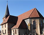
The Church of the Assumption of Our Lady ( Église Notre-Dame de l'Assomption ) was built in two phases: the steeple dates from around 1700, while the nave was built in Baroque style from 1726 to 1735 . The church is richly decorated (see: List of Monuments historiques in Phaffans ), including altars from the 17th century as well as statues and a pulpit from the 18th century. The rectory was built in 1701.
- Church of the Assumption


population
| Population development | |
|---|---|
| year | Residents |
| 1962 | 124 |
| 1968 | 136 |
| 1975 | 342 |
| 1982 | 350 |
| 1990 | 353 |
| 1999 | 315 |
| 2007 | 336 |
With 451 inhabitants (January 1, 2017) Phaffans is one of the small communities in the Territoire de Belfort. After the population had clearly decreased in the first half of the 20th century (200 people were still counted in 1896), a strong population growth was recorded from 1968 to 1975. After that, the number of inhabitants remained at an almost constant level, only to have increased significantly in recent times.
Economy and Infrastructure
Until well into the 20th century, Phaffans was a village dominated by agriculture (arable farming, fruit growing and cattle breeding). The hydropower of the Ermite and the Autruche was previously used to operate mills. In addition, there are now various small businesses. In the meantime the village has turned into a residential community. Many workers are also commuters who work in the Belfort agglomeration.
The village is well developed in terms of traffic. It is located on a departmental road that leads from Bessoncourt to Eguenigue. The closest connection to the A36 motorway , which crosses the municipality, is about five kilometers away. Further road connections exist with Denney, Lacollonge and Roppe.
literature
- Le Patrimoine des Communes du Territoire de Belfort. Flohic Editions, Paris 1999, ISBN 2-84234-037-X , pp. 158-159.