
Rougemont-le-Château
| Rougemont-le-Château | ||
|---|---|---|
.svg)
|
|
|
| region | Bourgogne-Franche-Comté | |
| Department | Territoire de Belfort | |
| Arrondissement | Belfort | |
| Canton | Giromagny | |
| Community association | Vosges du Sud | |
| Coordinates | 47 ° 44 ′ N , 6 ° 58 ′ E | |
| height | 422-1,031 m | |
| surface | 16.64 km 2 | |
| Residents | 1,479 (January 1, 2017) | |
| Population density | 89 inhabitants / km 2 | |
| Post Code | 90110 | |
| INSEE code | 90089 | |
| Website | http://www.rougemont-le-chateau.fr/ | |
 Mairie |
||

Rougemont-le-Château (German earlier Rothenburg , also Rotenberg ) is a commune in the department Territoire de Belfort in the region Bourgogne Franche-Comté and Canton Giromagny in the Arrondissement Belfort .
geography
Rougemont-le-Château is 446 m above sea level, about 14 kilometers northeast of the city of Belfort (as the crow flies). The village extends on the northern edge of the Burgundian Gate , on the plateau at the southern foot of the Vosges , at the foot of the Montagne des Boulles and on the Ruisseau de Saint-Nicolas . It is located in the Ballons des Vosges Regional Nature Park .
The area of the 16.64 km² large municipality includes a section in the area of the southern Vosges. The south-eastern part of the area is occupied by the plateau at the foot of the Vosges, which is an average of 440 m. Otherwise, the area has a strong relief and extends into the densely forested low mountain range of the Vosges. The most important flowing water is the Ruisseau de Saint-Nicolas, whose headwaters are located on the southern slope of the Baerenkopf . It receives tributaries from various short side valleys and erosion channels that subdivide the area and steps out onto the plateau at Rougemont-le-Château. The brook ensures the drainage of the area to the south via the Bourbeuse to the Allaine . The highest mountain in the catchment area of the Ruisseau de Saint-Nicolas is the Baerenkopf, on whose southern flank the highest point of Rougemont-le-Château is reached at 1031 m. To the west, the valley is bounded by its ridge, which extends to the south, with the Tête le Moine (790 m). In the north, the chain with the Montagne des Boulles (786 m) and the Sudel (914 m) forms the border with the Doller Valley .
Rougemont-le-Château includes the hamlet of Saint-Nicolas (537 m) on the stream of the same name at the southern foot of the Baerenkopf and a few individual farms. Neighboring municipalities of Rougemont-le-Château are Masevaux in the north, Leval in the east, Romagny-sous-Rougemont and Anjoutey in the south and Étueffont and Lamadeleine-Val-des-Anges in the west.
history
In the secluded valley of the Ruisseau de Saint-Nicolas, the priory Saint-Nicolas was founded in the 11th century, whose monks lived according to the rules of the Cistercians . Towards the end of the 12th century, the then Count of Ferrette had the Rougemont castle built on a ledge (736 m) of the Montagne des Boulles almost 300 m above the plain, which became the center of a lordship. At the foot of the mountain the settlement of Rougemont developed, once Latinized Rubro Monte and Rubens Mons (meaning red mountain because the Vosges sandstone in the area has a reddish color). This place was fortified in the middle of the 13th century and a second castle, the Château Bas, was built near the village.
In the middle of the 14th century, the rulership of Rougemont came under the sovereignty of the Habsburgs on the Habsburg-Laufenburg line . With the death of Johann IV von Habsburg , the rule of Rotenberg fell through marriage to Rudolf III. von Sulz from the family of the Counts von Sulz . The upper castle was probably besieged and sacked by mercenaries under Enguerrand VII. De Coucy at the end of the 14th century . During the Thirty Years War , Rougemont was ravaged and the Saint-Nicolas priory destroyed. Together with the Sundgau , the village and rulership came to the French crown with the Peace of Westphalia in 1648. Rougemont has belonged to the Haut-Rhin department since 1793, but in 1871 it remained as part of the Territoire de Belfort, unlike the rest of Alsace, in France, at which time it was separated from the canton of Masevaux and, together with the also francophone neighboring communities of Leval, Petitefontaine and Romagny, the new canton Rougemont-le-Château formed.

During the second half of the 19th century, the development from an agricultural community to an industrial location took place. In Rougemont, businesses in the textile industry, metal processing (locksmiths and foundries) and brickworks settled. After Alsace fell to the German Empire, Rougemont experienced heavy immigration by Francophile Alsatians. This led to an increase in the population from 1866 to 1891 by more than 50% to 2300 people.
To avoid confusion with other communities of the same name, Rougemont was officially renamed Rougemont-le-Château in 1893. In 1913, Rougemont was connected to the French railway network by a narrow-gauge railway line that led via Les Errues to Belfort. A few years before the Second World War, however, operations were stopped. Today Rougemont-le-Château is merged with 13 other municipalities to form the communal association Communauté de communes du Pays Sous Vosgien .
Attractions
The Saint-Pierre church was rebuilt in the neo-Gothic style from 1852 to 1868 . Remains of the Château-Bas and the ruins of the Château-Haut or the Rotenberg castle ruins from the 12th century, which were restored from 1981, have been preserved. The Sainte-Catherine chapel (built in 1876) is located near the Château-Haut by the spring of the same name. Today's Saint-Nicolas convent with its chapel dates from the 19th century.
See also: List of Monuments historiques in Rougemont-le-Château

Saint-Pierre church 
Interior of the church 
Sainte-Catherine Chapel 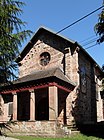
Saint-Nicolas, west side 
Saint-Nicolas, north side

.jpg)
.jpg)


population
| Population development | |
|---|---|
| year | Residents |
| 1962 | 1409 |
| 1968 | 1375 |
| 1975 | 1318 |
| 1982 | 1301 |
| 1990 | 1198 |
| 1999 | 1198 |
With 1,479 inhabitants (January 1, 2017), Rougemont-le-Château is one of the smaller municipalities in the Territoire de Belfort. After strong growth at the end of the 19th century, Rougemont-le-Château reached its highest level as early as 1900 with more than 2,300 inhabitants. Thereafter, the population continued to decrease sharply until 1990, with a decrease of 50%. Only in the last few years has a rising trend been observed.
Economy and Infrastructure
From the middle of the 19th century, Rougemont-le-Château developed into an industrial community. Today, various small and medium-sized businesses are based in the community, including construction businesses, mechanical workshops and a filter manufacturing company. There are also retail shops for daily needs. Many workers are also commuters who work in the agglomerations of Belfort and Mulhouse . Rougemont-le-Château is home to a college and a medical-pedagogical institute.
The village is away from the major thoroughfares. Regional roads connect Rougemont-le-Château with Belfort, Masevaux, Giromagny and Lachapelle-sous-Rougemont. The closest connection to the A36 motorway is around nine kilometers away.
literature
- Le Patrimoine des Communes du Territoire de Belfort. Flohic Editions, Paris 1999, ISBN 2-84234-037-X , pp. 234-238.