
Doller
| Doller | ||
 The Doller in Lauw |
||
| Data | ||
| Water code | FR : A12-0200 | |
| location |
France
|
|
| River system | Rhine | |
| Drain over | Ill → Rhine → North Sea | |
| source | northwest of the Baerenkopf in the area of the Alsatian Belchen (French Ballon d'Alsace) in the Vosges 47 ° 46 ′ 51 ″ N , 6 ° 54 ′ 21 ″ E |
|
| Source height | approx. 900 m | |
| muzzle | in Mulhouse in the Ill coordinates: 47 ° 45 '58 " N , 7 ° 19' 53" E 47 ° 45 '58 " N , 7 ° 19' 53" E |
|
| Mouth height | approx. 235 m | |
| Height difference | approx. 665 m | |
| Bottom slope | approx. 14 ‰ | |
| length | 46.5 km | |
| Catchment area | 215.4 km² | |
| Drain at the mouth |
MQ |
4.26 m³ / s |
The Doller is a 46.5 km long left tributary of the Ill in the French region of Grand Est .
geography
course

The Doller rises about 900 m northwest of the Baerenkopf in the area of the Alsatian Belchen (French Ballon d'Alsace) in the Vosges .
At this point she is already called Doller and takes the Wagenstallbach on her left. After turning in a wide arc of more than 180 °, it heads east-south-east in the Vallée de la Doller in the canton of Masevaux . The communities Sewen , Dolleren , Oberbruck , Kirchberg , Wegscheid , Niederbruck , Sickert , Masevaux and Sentheim are located in this valley . Outside the mountain system of the Vosges , the Doller changes its main direction slightly and flows towards the east. In Mulhouse it flows into the Ill at an altitude of about 235 m .
Tributaries


- La Kaltenbrunnen (left)
- Le Firtig (left)
- Latschgraben (right)
- Wagenstellbach (left)
- Seebach near Sewen (left), 2.5 km
- Graberbach (right), 3.4 km
- Seebach near Oberbruck (left)
- Soultzbach (left)
- Heimbach (left), 2.2 km
- Lachtelweiherbaechle (right), 4.9 km
- La Rohne (right), 1.6 miles
- Sickertbach (left), 3.1 km
- Odilenbaechle (right), 3.8 km
- Willerbach (left), 4.7 km
- Houppachbaechle (left)
- Grambaechle (right), 2.8 km
- Le Talungrunzbach (right) 2.7 km
- Silbach (left)
- Bourbach (left)
- Hahnenbach (right), 6.0 km
- Michelbach (left)
- Steinbaechel (right)
- Baerenbach (left)
Hydrology
At the confluence with the Ill, the mean flow rate (MQ) is 4.26 m³ / s; the catchment area here covers 215.4 km².
In Reiningue , the average annual runoff of the Doller was calculated over a period of 43 years (1967–2009) . The catchment area at this point corresponds to about 180 km², thus about 83.7% of the entire catchment area of the river.
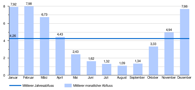
The flow rate of the Doller, with the annual average of 4.22 m³ / s, fluctuates quite strongly in the course of the year. The highest water levels are measured in the winter months from December to February. The flow rate reaches its peak in February with 7.98 m³ / s. From March onwards the discharge decreases month by month and reaches its lowest level in August of 1.09 m³ / s, after which it increases again from month to month.
The monthly mean discharge (MQ) of the Doller in m³ / s, measured at the hydrological station Reiningue.
Data calculated from the values for the years 1967 - 2009
Individual evidence
- ↑ Débits caractéristiques de la Doller
- ↑ see Débits caractéristiques de la Doller
- ↑ Banque Hydro - Station A1252010 - La Doller à Reiningue, (menu item: Synthèse)
Web links
- Doller at SANDRE (French)
- Débits caractéristiques de la Doller (French; PDF; 19 kB)