Ill (Alsace)
The Ill , sometimes also written Jll to distinguish the leading I , is a left tributary of the Rhine with a length of almost 217 kilometers and an average water flow of over 54 m³ / s. It runs in the departments of Haut-Rhin and Bas-Rhin in the Grand Est region (until 2015 Alsace ).
A special feature of the river is the strong discharge of the estuary , due to which the Ill flows several kilometers parallel to the banks of the Rhine river.
geography
course
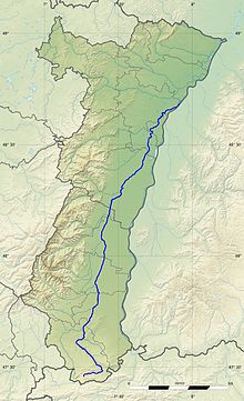
The source of the Ill lies in the Jura ( Pfirter Jura ), below the Sundgau community of Winkel . Shortly after its origin, the Ill flows eastwards. Between Raedersdorf and Oltingue , near the Swiss border , the stream changes its main direction and flows to Altkirch to the northwest. The direction of flow between Altkirch and the mouth is then predominantly north-northeast, between the Rhine in the east and the Vosges in the west. The Ill now flows through the central areas of Alsace. In Strasbourg and below, tributaries split off three times over a shorter distance: in the area of the old town to the north the Fossé du Faux-Rempart (Falschwall Canal or Stadtgraben), below the old town to the west the Aar and even further down the Ill at the level of Strasbourg-Robertsau East the mill water . Until the early 1970s, the Ill flowed into the Rhine opposite Diersheim . Due to the impoundment of the Rhine near Gambsheim , the Ill had to be lengthened and becomes a Canal de Dérivation (diverter), which leads its water past the Gambsheim barrage and empties into the Rhine in the area of the municipality of Offendorf at Rhine km 311,300. Already from La Wantzenau there is Altwasser to the left of the Ill , which has the part of the name “-rhein”: Waldrhein, Hanauerrhein, Muehlrhein (here the German spelling has been retained on French maps and information boards). Existing arms of the old Rhine were partially used for the Ill extension.
Tributaries and canals
The main tributaries all flow from the left and come from the Vosges, with the exception of the Largue, which, like the Ill, rises in the Jura. The Ill takes almost all Alsatian Vosges rivers. Its main tributaries are: Largue , Doller , Thur , Lauch , Fecht , Giessen , Andlau , Ehn and Breusch (French: la Bruche ).
Two important channels intersect the Ill: at Illfurth (above Mulhouse) by the Burgundy Gate withdrawing Rhone-Rhine Canal and Strasbourg, below the Old Town, leading to Lorraine Rhein-Marne-channel .
Cities
Many important Alsatian cities are on or in the immediate vicinity of the Ill; with Mulhouse ( Mulhouse ), Colmar and Strasbourg ( Strasbourg ) three of the four large and medium-sized cities (excluding Hagenau / Haguenau ), with Altkirch and Schlettstadt / Sélestat two of the most important small towns. The former residence town of Ensisheim is also located on the Ill.
Hydrology
At the confluence of the Ill into the Rhine, the mean flow rate (MQ) is 53.7 m³ / s; the catchment area here covers 4760.5 km².
At the Strasbourg gauge , the average annual discharge of the Ill was calculated over a period of 37 years (1974–2010) . The catchment area at this point corresponds to about 97% of the complete catchment area of the river with 4600 km².
The flow rate fluctuates very little over the course of the year. The highest water levels are measured between December and March. The flow rate reached its peak in February at 69.4 m³ / s. From April onwards, the discharge fell slightly month by month and reached its lowest level in August / September at 49.6 m³ / s, after which it rose again slightly from month to month.
data calculated from the values from 1974-2010:

Others
- Between Winkel and Ligsdorf , the Ill flows underground for around 500 meters. The reason is the infiltration in the water-permeable Jura rock .
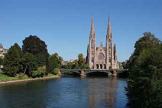
- At the intersection of the Ill and the Marne-Rhine Canal in Strasbourg there are important European institutions: the European Parliament , the Council of Europe and the European Court of Human Rights.
- The name of the Ill can be found in the place names of the following settlements: Illfurth , Illzach , Illhaeusern , Illkirch-Graffenstaden .
- A common explanation derives the name Alsace from the Ill. As a result, those Alemanni, who settled to the right and left of the Ill during the migration period , called themselves the Ill-Sassen , from which the landscape name is said to have originated.
- In French , the river name is male.
- Another, shorter but larger tributary named Ill flows into the Rhine in Vorarlberg .
Web links
- Ill at SANDRE (French)
- Débits caractéristiques de l'Ill (French; PDF file; 35 kB)
Individual evidence
- ↑ Note: Values of the Chasseur Froid (Strasbourg) level in relation to the entire catchment area (arithmetically: 55.57 m³ / s, due to the low area runoff in the lowest catchment area (mq) rather around 54.5 m³ / s)
- ↑ Ahnert, F. (2009): Introduction to Geomorphology. 4th edition, 393 pp.
- ↑ Banque Hydro - A2280350 L'Ill à Strasbourg (Chasseur Froid, La Robertsau) (menu item: Synthèse)


