
Leek (river)
|
Leek upper course: Durrenbach |
||
 The catchment area of the leek |
||
| Data | ||
| Water code | FR : A15-0200 | |
| location |
Vosges
|
|
| River system | Rhine | |
| Drain over | Ill → Rhine → North Sea | |
| source |
Vosges (Markstein) 47 ° 57 ′ 2 ″ N , 7 ° 2 ′ 5 ″ E |
|
| Source height | approx. 1229 m | |
| muzzle | at Colmar in the Ill Coordinates: 48 ° 5 ′ 37 ″ N , 7 ° 23 ′ 1 ″ E 48 ° 5 ′ 37 ″ N , 7 ° 23 ′ 1 ″ E |
|
| Mouth height | 180 m | |
| Height difference | approx. 1049 m | |
| Bottom slope | approx. 22 ‰ | |
| length | 46.7 km | |
| Catchment area | 390.1 km² | |
| Drain at the mouth |
MQ |
2.77 m³ / s |
| Medium-sized cities | Colmar | |
| Small towns | Guebwiller , Rouffach | |
 The leek in Lautenbach. |
||
 The leek in Issenheim |
||
 The leek reservoir |
||
The Leek is a 47 km long left tributary of the Ill in Alsace ( Grand Est region ).
geography
course
The leek rises on the eastern slope of the Vosges on the slopes of Markstein . Later in a dam since 1894 dammed the river to Lauchsee before through the valley of the leeks, and Florival called Guebwiller and Rouffach reached. In Colmar , the leek then flows into the Ill .
Catchment area
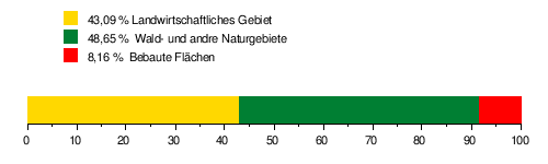
The Zorn catchment area is 390.1 km² and consists of 43.09% agricultural area, 48.65% forest areas and 8.16% built-up areas.
Tributaries
The most important tributaries are the Ohmbach , the Lohbach and the Alte Thur , a tributary of the Thur .
- Tributaries of the leek downstream
- Jungfrauenrunz ( right ), 0.9 km
- Hirsengrabenrunz ( right ), 2.2 km, 34 km²
- Klinzrunz ( left ), 1.6 km
- Rehgrabenrunz ( right ), 1.3 km
- Melt Wrinkle ( left )
- Belchenseebach ( right ), 3.9 km
- Hoellrunz ( left )
- Schellrunz ( left ), 2.0 km
- Felsenbach ( right ), 3.8 km
- Belchenbach ( left )
- Gross Sulzbach ( left ), 1.6 km
- Klein Sulzbach ( left )
- Gegenbach ( right ), 1.4 km
- Durrenbach ( left )
- Krebsbach (left)
- Murbach ( Breitenbachrunz ) ( left ), 6.3 km
- Lachmattenbach ( right )
- Ohmbach ( left ), 9.2 km, 64.8 km², 0.14 m³ / s
- Lohbach ( right ), 18.6 km. 93.0 km², 0.24 m³ / s
- Fallbach ( left )
- Vieille Thur ( Alte Thur ) ( right ), 25.9 km, 65.5 km², 0.59 m³ / s
Web links
Commons : Leek (river) - Collection of images, videos and audio files
- Débits caractéristiques de la Lauch (French; PDF file; 28 kB)