Thur (Ill)
| Thur | ||
|
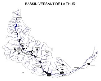
The catchment area of the Thur |
||
| Data | ||
| Water code | FR : A14-0200 | |
| location |
France
|
|
| River system | Rhine | |
| Drain over | Ill → Rhine → North Sea | |
| source | In the Vosges , near Wildenstein 48 ° 0 ′ 10 ″ N , 6 ° 58 ′ 13 ″ E |
|
| Source height | approx. 950 m | |
| muzzle | At Ensisheim in the Ill coordinates: 47 ° 52 ′ 34 ″ N , 7 ° 20 ′ 35 ″ E 47 ° 52 ′ 34 ″ N , 7 ° 20 ′ 35 ″ E |
|
| Mouth height | approx. 210 m | |
| Height difference | approx. 740 m | |
| Bottom slope | approx. 14 ‰ | |
| length | 53.3 km | |
| Catchment area | 261.7 km² | |
| Discharge at the Pulversheim A Eo gauge : 250 km²
|
NNQ (May 2011) MQ 1975 - 2014 Mq 1975 - 2014 HHQ (01/14/2004) |
580 l / s 6.09 m³ / s 24.4 l / (s km²) 153 m³ / s |
| Discharge A Eo : 261.7 km² at the mouth |
MQ Mq |
5.18 m³ / s 19.8 l / (s km²) |
| Small towns | Thann , Cernay , Ensisheim | |
|
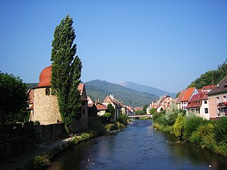
The Thur in Thann |
||
|
The Thur in Kruth |
||
|
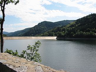
Reservoir of the Krüth-Wildenstein reservoir |
||
The Thur is a 53 km long left tributary of the Ill in Alsace ( Grand Est region ).
geography
course
The Thur rises in the Vosges on the southwest flank of the Rainkopf north of Wildenstein . In Kruth 1959-63 a dam was built to the drain especially after the snow melts to regulate. This created the Lac de Kruth-Wildenstein .
The Thur then flows through the Thurtal , formerly often called St. Amariner Tal , (Vallée de la Thur), past Saint-Amarin , Thann and Alt-Thann before entering the Upper Rhine Plain and turning northeast at Cernay . Below Ensisheim it flows into the Ill . An arm branching off in front of the mouth flows further north as the Alte Thur , past Rouffach and flows into the Lauch below Pfaffenheim . This is the main reason why the Thur has an average of around one sixth less water at its mouth than at the Pulversheim gauge (a good 6 m³ / s).
Tributaries
- Herzrunz ( left ) (via Lawinenrunz 1.1 km)
- Kleinrunz ( left )
- Grossrunz ( left )
- Behind Bockloch ( right ), 2.6 km
- Vorder Bockloch ( right ), 1.6 km
- Tieferunz ( right ), 1.4 km
- Heidelbeerenloch ( right ), 2.0 km
- Frenzlochrunz ( right ), 1.7 km
- Steinlerrunz ( left ) (via Runscherunz 4.8 km) '
- Ruisseau de Saint-Nicolas ( right )
- Gottrunz ( left ), 3.1 km
- Rammersbach ( right ), 5.3 km
- Seebach ( right ), 7.6 km
- Rimbachrunz ( right ), 5.8 km
- Bruscherrunz ( left )
- Dorfbach ( right ), 4.4 km
- Hirschenbach ( right )
- Hintervogelbach ( left )
- Waldrunz ( right ), 5.2 km
- Bachmattrunz ( left ), 3.9 km
- Altrainrunz ( right ), 3.4 km
- Wissbach ( left ), 7.6 km
- Erzenbach ( left )
- Kerlen ( right ), 5.2 km
- Grumbach ( left ), 1.2 km
- Finsterbach ( left ), 2.8 km
- Steinbyrunz ( right ), 4.7 km
- Erzenbach ( left )
- Egelbach ( left )
- Silberlochrunz ( left )
- Veidruntz ( right ), 1.8 miles
Hydrology
At the confluence of the Thur and Ill , the mean discharge rate (MQ) is 5.18 m³ / s; the catchment area here covers 261.7 km².
At the Pulversheim gauge , the average annual runoff of the Thur was calculated over a period of 35 years (1974–2009) . The catchment area at this point, with 250 km², corresponds to about 95.5% of the entire catchment area of the river.
The flow rate fluctuates quite strongly over the course of the year. The highest water levels are measured between December and March. The flow rate reached its peak in January at 11.40 m³ / s. From April onwards the discharge decreases month by month and reaches its lowest level in August with 2.04 m³ / s, after which it increases again from month to month. The annual average value here is 6.19 m³ / s.
The monthly mean discharge (MQ) of the Thur in m³ / s, measured at the hydrological station Pulversheim.
Data calculated from the values for the years 1974–2009

Individual evidence
- ↑ Thur at SANDRE (French)
- ↑ a b see web link: Débits caractéristiques de la Thur
- ↑ Banque Hydro - A1462050 La Thur à Pulversheim (menu item: Synthèse)
Web links
- Débits caractéristiques de la Thur (French; PDF; 23 kB)


