
Kruth
| Kruth | ||
|---|---|---|
.svg)
|
|
|
| region | Grand Est | |
| Department | Haut-Rhin | |
| Arrondissement | Thann-Guebwiller | |
| Canton | Cernay | |
| Community association | Vallée de Saint-Amarin | |
| Coordinates | 47 ° 56 ' N , 6 ° 58' E | |
| height | 468-1,263 m | |
| surface | 22.06 km 2 | |
| Residents | 941 (January 1, 2017) | |
| Population density | 43 inhabitants / km 2 | |
| Post Code | 68820 | |
| INSEE code | 68171 | |
| Website | http://www.kruth.fr/ | |
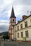
 Mairie Kruth |
||

Kruth (German: Krüt ) is a French commune with 941 inhabitants (as of January 1, 2017) in the Haut-Rhin department in the Grand Est region (until 2015 Alsace ). It belongs to the Arrondissement Thann-Guebwiller , the canton of Cernay and is a member of the municipal association Vallée de Saint-Amarin .
geography
Kruth is located in the upper Thur valley near the Vosges ridge . The highest points are the Markstein at 1266 and the Grand Ventron at 1204 m above sea level. To the north of Kruth lie the Lac de Kruth-Wildenstein and the Wildenstein castle ruins . From Kruth, a pass road leads over the Col d'Oderen to Ventron in neighboring Lorraine . The municipality of Kruth is part of the Ballons des Vosges Regional Nature Park .
The railhead Kruth is the terminus of the railway line Lutterbach-Kruth that Kruth about Thann and Cernay with Mulhouse connects.
history
From 1871 until the end of the First World War , Kruth belonged to the German Empire as part of the realm of Alsace-Lorraine and was assigned to the district of Thann in the district of Upper Alsace .
Population development
| year | 1910 | 1962 | 1968 | 1975 | 1982 | 1990 | 1999 | 2007 | 2017 |
| Residents | 1,475 | 899 | 1,094 | 1.012 | 1.002 | 976 | 1.010 | 1,019 | 941 |
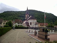
- St. Wendelin Church in Kruth


literature
- Le Patrimoine des Communes du Haut-Rhin. Flohic Editions, Volume 2, Paris 1998, ISBN 2-84234-036-1 , pp. 1048-1049.