Wattwiller
| Wattwiller | ||
|---|---|---|

|
|
|
| region | Grand Est | |
| Department | Haut-Rhin | |
| Arrondissement | Thann-Guebwiller | |
| Canton | Cernay | |
| Community association | Thann-Cernay | |
| Coordinates | 47 ° 50 ′ N , 7 ° 11 ′ E | |
| height | 266-1,121 m | |
| surface | 13.61 km 2 | |
| Residents | 1,634 (January 1, 2017) | |
| Population density | 120 inhabitants / km 2 | |
| Post Code | 68700 | |
| INSEE code | 68359 | |
 Mairie Wattwiller |
||
Wattwiller ( German Wattweiler , Alsatian or Alemannic: Wăttwillr ) is a French commune with 1634 inhabitants (as of January 1, 2017) in the arrondissement of Thann-Guebwiller in the Haut-Rhin department in the Grand Est region (until 2015 Alsace ).
The place is known for its springs, which were already used by the Romans , and its mineral water .
geography
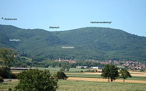
The place lies at the foot of the Hartmannswillerkopf , one of the most contested theaters of war in Alsace during the First World War . The municipality is part of the Ballons des Vosges Regional Nature Park .
The village is located on the lower foothills of the South Vosges , in a transition area between mountain slopes and the Rhine plain. The settlement had originally started on the gentle slope next to a mountain stream (Siehlbach). The conical Hirtzenstein (571 m) with its rock, the rocky elevation Herrenfluh (857 m) with its elongated protrusion Eichwald-Nodelberg-Mamberg and, a little further, the slopes of the Molkenrain (1126 m) and the Hartmannswillerkopf (956 m) combine the mountain scenery in the background.
The valley of the Siehlbach also forms the catchment area for the superficial and seeping waters,
which after a long time become mineral water through their underground course.
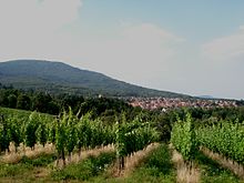
The town center is at a height of about 360 meters, but the municipality extends up to the heights of the Molkenrain (1125 m). The forest cover on the mountain slopes consists of a mixed forest in which the deciduous trees predominate. Agricultural soils are located on the southern and eastern parts of the municipality in the flatter terrain and are used for agriculture and cattle breeding . The Weckenberg and Nodelberg foothills are suitable for viticulture and have been planted with vines and fruit trees since ancient times .
The branch in France of the Loos International Group (boiler systems for steam and hot water) and the modern equipment for the water filling plant are located on the commercial site along Weinstrasse (D 5). In addition, the individual commercial establishments mainly relate to the construction industry.
A 4-star campsite is set up above the village in the middle of the forest. Around 150 shady parking spaces, rental apartments, several recreational sports facilities, two swimming pools, a riding school and a restaurant are spread over an area of 15 hectares.
geology
The geological basis of the Wattwiller district can only be understood in connection with the tectonics of the Vosges massif and the Rhine valley. Due to the slow and extensive subsidence of the Upper Rhine Valley, there has been a vertical shift since the Eocene between the "old" Hercynian - Variscan Vosges massif and the "younger" deposits that have since filled up on the base of the Rhine trench. Thus , the rocks from the Paleozoic are now at higher altitudes than those from the Quaternary and Cenozoic deposits in the Upper Rhine Valley .
Due to these tectonic movements, the foot of the mountain is characterized by two main faults : the Vosges breach (faille vosgienne) and the Rhine valley breach (faille rhénane).
The upper sections of the Molkenrains and the Hartmannswillerkopf are known to consist of volcanic rocks , which were caused by volcanic activity in the lower Carboniferous , i.e. H. at visa time , testify. These are effluent rocks rich in feldspar , such as quartz-containing latites , which have arisen from lava flows and are alternately piled up with pyroclastic deposits, the so-called ignimbrites . This structure corresponds to the basic pattern of a former stratovolcano .
Granite outcrops that have risen from the depths are not in the immediate vicinity, but a little further near Goldbach-Großbelchen.
In the slightly lower locations, e.g. B. in the Siehlbachtal, there are also marine sedimentary rocks that were created by the deposition of fine-grained fragments of clastic and volcanic origin. In a broader sense, one speaks of greywacke , which, however, can have different components depending on the location. Along the Vosges Mountains, the crushing of the primary rock has resulted in the formation of a quartz-containing breccia - as it is e.g. B. occurs at the Hirtzenstein - this is a consequence.
At the head of the sand pit, some outcrops of red sandstone and conglomerates from the Triassic period remain. The Weckenberg and Nodelberg hills consist of conglomerates, some of which originate from the Oligo and Pliocene .
The vast, slightly inclined glacis , located on the mountain edge , is covered with colluvial deposits from the Pleistocene (interglacial periods of the Middle Quaternary). Here and there sparse remains of the loess cover are still present, whereas the neighboring municipality of Berrwiller has a thicker (2 to 4 m) and less loose layer of loess.
In the spring area of the mineral springs, the repeated drilling encountered marl , gypsum and lime layers of the Keuper and - further down - the considerable lime layer of the shell limestone .
See also: Geological timescale
history
The origin of the village of Wattwiller is linked to the presence of thermal springs . These may already have been known to the Celts , but most certainly to the Romans, as the discovery of roof tiles and water pipes from this era in 1874 indicates this. The name Wattwiller could be derived from the sources (Wattwiller = water hamlet?). It is more likely that the place name comes from a certain Watto , a head of the Alamanni or the Franks . “Willer” comes from the late Latin “villare” ( Gallo-Roman settlement). At the end of the fifth century a monk preaching the gospel migrated to this place and established a first place of Christian worship there.
From the Middle Ages to the First World War
The first written mention of the village comes from the year 727. Several monasteries owned property there, in particular arable and wine-growing land. In 735, the "Wattonvillare" fiefdom was temporarily assigned to the Murbach monastery by Count Eberhardt . For some time it belonged to the Habsburg rule until it was annexed to the abbey property again in 1259.
Around 1270, the abbot of Murbach had Wattwiller surrounded with fortifications and then elevated the village to a town. At the same time the castles Weckenberg, Herrenfluh and Hirtzenstein were built on the surrounding elevations.
The history of Wattwiller is marked by battles, looting and mass murders. So it was, for example, in 1375 with the "English troops" of Enguerrand de Coucy and in 1444 with the Armagnacs riders. At Easter 1445 these were fought in the Nonnenbrucherwald near Sennheim / Cernay by the residents with the help of those from Thann, Sennheim and Sultz until they were defeated. In 1468 the city besieged by the Swiss had to surrender and unite with Switzerland.

On September 5, 1525, during the peasant uprising, the fortified city was stormed by the peasants from the Sundgau, but the inhabitants beat it back with the help of Mr. von Hirtzenstein.
During the Thirty Years War (1618-1648) the place suffered a lot. On March 2, 1634, the imperial troops delivered a bloody battle to the Swedish troops on the municipal ban, which left 1,500 dead. After their victory, the Swedes storm the city wall, loot and commit murder and manslaughter. In 1652 it is the Lorraine people who devastate Wattwiller after a brief attack. After the Peace of Westphalia , the city was annexed to France with Alsace in August 1680.
After a long and peaceful period during the 18th century, the feudal era ended with the administrative reorganization of the French Revolution (1789/90), and with it the rule of Murbach Abbey.
Happened in the First World War
Because of its important location, the Hartmannswillerkopf was fought over from December 1914 to January 1916. The villages of Uffholtz, Wattwiller, Wuenheim and Hartmannswiller at its foot were repeatedly hit hard by the projectiles.
Since the positional war lasted for a long time, the German army made Wattwiller an important supply base . In order to transport the required material, a narrow-gauge railway was built from the Sultz train station to a point in the Wattwiller Forest. Not far from the village in the nearby forest area, numerous soldiers' camps were set up. A German management staff occupied all buildings of the bathing establishment.
Because of the constant bombing, the population had to be evacuated in December 1914. When the inhabitants returned at the end of the war, they came across a completely destroyed village. They lived partly in the smashed houses, partly in wooden barracks. The reconstruction lasted until the 1930s.
War cemeteries from the time of the battle for the Hartmannswillerkopf are Nécropole nationale du Silberloch - Hartmannswillerkopf , German war cemetery Cernay and the war cemetery Guebwiller .
Population development
| year | 1962 | 1968 | 1975 | 1982 | 1990 | 1999 | 2007 |
| Residents | 879 | 1,020 | 1,135 | 1,186 | 1,506 | 1,593 | 1,721 |
Partnerships
Wattwiller has been in a partnership with the German town of Wasenweiler am Kaiserstuhl , which has been part of the Ihringen community since 1974 , since 1965 .
Mineral water production
The occurrence of mineral water was already known in Roman times and was in all probability used as drinking or bath water at that time. The springs are located at the foot of the South Vosges , on the edge of a nature park , whose industrial and agricultural-free area is subject to strict protective measures.
The groundwater seeps through various volcanic rocks from the Paleozoic , as well as layers of gypsum and limestone from the Keuper and Muschelkalk . This enriches the natural water with valuable minerals before it comes back to the earth's surface. The entire spring catchment area is shielded from the surface seepage water by a layer of clay created from the Quaternary . This means that the groundwater remains free of nitrates and germs .
Half-deep boreholes bring the water to light: In the past century, it was extracted through the two springs “Arsène” and “Lithinée”. The current source is called "Artesia" and is about 220 meters below the surface of the earth.
Further deep drilling has been carried out in recent years near the main geological fault to reveal warm thermal water . Although the drilling was unsuccessful in this regard, it also turned out that the underground water reservoir is considerable.
In the course of time, the abbots of Murbach first took possession of the spring from the 15th century onwards, until they handed over the administration to the "city" of Wattwiller in 1522. At the beginning of the 14th century, the powerful abbey had elevated the place to a permanent city. From then until 1712, a so-called bath room was operated in what was then known as the “Badviertel”.
Around 1760 there was a temporary boom thanks to the expansion and renovation of the institute and after the announcement of an initial analysis of the mineral water. Every now and then there were setbacks and the bathing establishment changed hands several times.
In 1866, the mayor Joseph de Gohr acquired the entire complex and initiated several construction works for more modern facilities as well as the construction of three villas in the immediate vicinity. The new heyday lasted until the beginning of the 20th century.
Most of the spa guests came from Upper Alsace, sometimes from a greater distance. But the considerable destruction of the village and the spa buildings by the bombings in World War I meant the end of the use of all facilities.
In 1925 a building was built near the Quellenpark in which a bottle filling system was put into operation. The mineral water known under the name "Lithia" was marketed in stores until 1975. The last big boom began in 1993 with the construction of a new bottling plant. Since then, the multinational operates Group spadel bottling and marketing mineral water nationwide under the trademark "Wattwiller".
Catholic Church
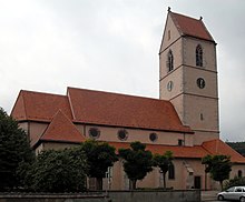
The Catholic church, built in the 15th century, consecrated in 1481 and dedicated to John the Baptist , has been a listed building since 1930 ( Monument historique ). Architecturally, it consists of a mixture of Romanesque and Gothic styles. Remains from older times have been preserved in the lower structure, such as the crypt from the 13th century and foundation parts of a Romanesque apse . The church has a wood-carved winged altar , a tomb of the nobles of Wattweiler and a Rinckenbach organ.
An earlier church, built in the 13th century, already stood on the same site. It had a similar bell tower, a nave and a Romanesque choir. But it hardly survived the troubled times of the Hundred Years' War .
Next to the main portal, a stone with a carved inscription reminds of the year 1481, when the old crumbling structure was rebuilt and enlarged. The numbers were carved in the then common Alemannic spelling.
The church building consists of a main nave , a Gothic choir, two side aisles and a bell tower. Two side chapels were added in 1852 on one and the other side of the bell tower, slightly deviating from the alignment of the corresponding aisles.
An even older chapel, the Sebastian Chapel, the foundation of which dates from the 13th century, flanks the choir on the north side. It is connected to the first yoke of the aisle on the same level by an arched passage. Under this yoke and under the Sebastian chapel there is a vaulted crypt in which the oldest parts of the original structure can be seen. Since the floor level of the choir and the Sebastian chapel is four steps higher than that of the nave, the vault of the crypt in the yoke part was raised by a terrace-like superstructure. Enclosed by a beautiful wrought-iron grating, this addition is roughly at the same floor level as the adjacent Sebastian Chapel.

Pair of windows with Gothic pointed arches
|
If you descend from the side aisle to the partially subterranean crypt , you first come to a first room that has remains from Romanesque times, including a two-part window of early Romanesque design (9th century). This room served as an ossuary for several centuries . The second room, which is located under the Sebastian Chapel, shows a pair of windows with fine Gothic pointed arches (12th century) and, on the inner side, the oldest component of this church: a rounded approach that leads to the semicircular apse of the Merovingian early church (7th century) . Century) and the part behind it extends under today's choir.
The high altar wearing a wing images set of Gothic design since 1,901th This wood carving masterpiece was made by the famous workshop Theophil Klem from Colmar. After unfolding the wings, the reredos can be looked up from right to left in comparison to the oriental books.
Four panel paintings depict the life of John the Baptist in high relief with quotations from the Bible:
- The circumcision ceremony in the temple: "Joannes est nomen ejus"
- The sermon in the desert: "Parate viam Domini"
- The meeting of John and Jesus on the Jordan: "Ecce Agnus Dei"
- The beheading of John on Herod's command: "Decollavit Joannem"
Another work of art, this time from the 14th century, is located in the first section (yoke) of the south aisle. It is the grave slab with elaborately carved reliefs of Anna von Wattweil, who died in 1344, wife of the knight and Vogts Rudolf.
Way and road crosses
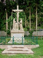
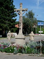
In pious times, several wayside crosses or wayside shrines were laid out around the village. The three most beautiful and best preserved are currently in the houses near the village center. They are stone works of art, two of which are Golgotha representations, i. H. with the crucified as the central figure and the statues of the mourners standing next to it.
Cross on the Dürrenberg
The dainty Golgotha cross has stood at the upper exit of the village, opposite the spring collection system. It was badly damaged by bullets during the First World War, but was repaired again in 1933. A few meters away there is a hiking board made by the Vosges Club, which offers hikers and tourists detailed information.
Indulgence Cross
An indulgence cross is located on the main street opposite the “ Katia & Maurice Krafft ” building.
On the pedestal, the instruments of torture of the crucifixion of Christ are shown in relief, and the saying inviting prayer is carved into a stone slab. The cross was erected at the same time as that of the Dürrenberg and inaugurated at this point in 1861.
Thierenbacher Cross
Called "Thierebǎcher-Kritz" by the inhabitants because of its location on the former Thierenbacherweg. Two statues made of gray-yellow sandstone complement the image of a Golgotha cross. One is probably the original from the 19th century, the other had to be replaced after the First World War.
It should be mentioned that the way to Thierbach as well as the "Rue de Thierbach" from time immemorial as a pilgrimage apply: Every year on the third Sunday after Pentecost pilgrimage the Catholic community - because of their vow of a difficult year in 1797 - the pilgrimage of Basilica to Thierenbach . In addition, this route is one of the more frequently committed Way of St. James , of the Vosges along to Thann and then on to Cluny and Santiago de Compostela leads.
Village fountain
Nepomuk fountain
Four old wells in good condition are part of today's town center, as they were built within the former city wall in earlier times. The Nepomuk fountain between the church and the rectory is probably the oldest of these - it was mentioned as early as 1487, when the church was being rebuilt. It consists of a large octagonal and a smaller rectangular basin, both made of red sandstone . The water flows from two outflow pipes that are attached to the column topped by the statue of St. Nepomuk . Thus this fountain belongs to the so-called stick fountain.
Gohr fountain
It is located in front of the entrance to the palace courtyard of the von Gohr nobles. It was built in 1577 instead of an even older well. The erected wayside shrine , a statue of the then prince abbot von Murbach , was damaged several times and finally fell apart after the First World War. All that remained was the column with a spout. The octagonal basin made of red sandstone is - like each of the two other stick fountains - bordered with iron bars.
Sebastian fountain
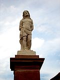
This is about the youngest, but perhaps the most beautiful stick fountain, whose good location on the village square, also known as “Tuechbleich”, has an advantage. Its octagonal basin and its central column with a statue of Saint Sebastian were built in 1866.
The structure withstood all the dangers of both wars until an unfortunate incident occurred in 2006: During a violent storm on June 25 of this year, an old, weakened linden tree fell on the column and caused serious damage. The red sandstone statue of St. Sebastian had to be replaced by a new statue made of white stone. Since then, the fountain with its four outflow pipes has adorned the newly prepared square, where the friendship stone Wattwiller-Wasenweiler has also found its place.
Hirtzenstein
The hill Hirtzenstein (570 m) gained historical importance over time. From the Middle Ages to the present, something always happened on this “little local mountain”.
From a geological point of view, it is already characterized by its outstanding quartzite rock . The main fault (faille vosgienne) between the Vosges massif and the Rhine plain is responsible for this. No wonder that the prince abbots of Murbach had a castle built on this "stone" in 1265. After the fief was handed over to the nobles von Wattwiller, the castle was stormed several times: in particular by the Confederates (1468), then later by the rebellious peasants (1525) and finally by the throngs of the Thirty Years' War, who left nothing but ruins.
In times of peace, the Hirtzenstein was used for agriculture: the lower slope, called Dürrenberg, was planted with vines, the saddle behind the quartzite rock served as a sheep farm , the surrounding forest provided firewood.
The Hirtzenstein was not spared in the battles for the Hartmannswillerkopf . German troops installed a support and observation post. They pierced the rock to set up shelters and tunnels.
When it was all over again, a hosted house with holiday apartments (Maison familiale de vacances) was built on the cleared saddle. The entire property has been owned by the Society for Mineral Spring Utilization since 1999.
Uhlan cemetery
The so-called Ulanenfriedhof is located on a wooded mountain slope not far from the Hirtzenstein. It is only a few meters away from the municipal boundary between Wattwiller and Hartmannswiller .
At this point, close to a lancier camp, in April 1915, forced by necessity, German soldiers had to be temporarily buried. In addition to some Uhlans , there were mainly soldiers and NCOs of the 56th Landwehr Infantry Regiment and the 4th Guards Jäger Battalion. After the war, the corpses were moved to another cemetery.
Due to its location in the forest and its well-preserved steles made of carved granite stone, this place has become a special kind of memorial.
Positions and shelters
There are numerous trenches, tunnels, positions and shelters on the porphyry ridge and on the slopes of the Hartmannswillerkopf. Some are well preserved, others have been repaired, others have fallen into disrepair. On the slope facing Wattwiller you can visit the following sites:
- the "Lippe Switzerland", a walled trench that meanders from the "Dickbuchenweg" (560 m) to the "Unteren Rehfelsen" (766 m),
- the steep "Himmelsleitergraben" and its continuation, the "Weihnachtsgraben", which connect the "Mittlere Rehfelsen" (820 m) with the summit area (956 m),
- the "Bamberg" festival above the "Untere Rehfelsen" (766 m),
- the festivals "Ratz", "Grand Duke" and "Rohrburg" on the "Porphyry Ridge",
- the "lookout rock" with "Monument du 152e RI" (920 m),
- the "Monument Serret" (760 m),
- "Fortin Mégard",
- "Fortin Sermet",
- "Roche Amic".
The last three are protected positions on the French side.
Personalities associated with the place
The volcanologists Katia and Maurice Krafft bought a residence in Wattwiller in 1977, to stay there between two expeditions or two lectures. In it they piled up a huge number of films, pictures, rock collections and documents of all kinds. On June 3, 1991, both of them had a fatal accident on the Unzen (Japan) due to a sudden pyroclastic current .
Since then, the multi-purpose building has been named after her to commemorate her ties to the village.
Joseph Remy (1857-1936) was a member of the state parliament and mayor of Wattwiller.
literature
- Le Patrimoine des Communes du Haut-Rhin. Flohic Editions, Volume 1, Paris 1998, ISBN 2-84234-036-1 , pp. 166-176.
See also
Web links
- More information about Wattwiller (private site)
- History and geology of the mineral water company Wattwiller (French and Alsatian or Alemannic)
Individual evidence
- ^ Carte géologique de la France à 1/50 000, feuille de Thann - BRGM Editions, avenue Claude-Guillemin - 45060 Orléans
- ↑ Musée de la Porte de Thann 1 rue de Thann 68700 Cernay
- ↑ German name at that time Hartmannsweilerkopf
- ^ Community of Ihringen am Kaiserstuhl ( Memento from June 6, 2010 in the Internet Archive )
- ↑ Wattwiller, source de vies - Collection Mémoire de vies - Carré Blanc Editions - Strasbourg
- ^ France: Spadel acquires water company Wattwiller. In: just-drinks. January 26, 2004 (English).
- ↑ Pierre Riether: Mon clocher raconte. And your own documents.
- ^ Basilique Notre Dame de Thierenbach - fr. -eng.- de.
- ↑ Stage n ° 10: Guebwiller (68) - Thann (68) ( Memento from October 11, 2010 in the Internet Archive )
- ↑ Carte G.Schultz 6e éd.1992 Les Amis du Hartmannswillerkopf 7, rue Gabriel Fauré F 68200 Mulhouse / War site plan of Hartmannswillerkopf G.Schultz

