
Orschwihr
| Orschwihr | ||
|---|---|---|
.svg)
|
|
|
| region | Grand Est | |
| Department | Haut-Rhin | |
| Arrondissement | Thann-Guebwiller | |
| Canton | Guebwiller | |
| Community association | Region of Guebwiller | |
| Coordinates | 47 ° 56 ' N , 7 ° 14' E | |
| height | 225-573 m | |
| surface | 7.09 km 2 | |
| Residents | 1,043 (January 1, 2017) | |
| Population density | 147 inhabitants / km 2 | |
| Post Code | 68500 | |
| INSEE code | 68250 | |
| Website | http://www.mairie-orschwihr.info/ | |
 Mairie Orschwihr |
||

Orschwihr ( German Orschweier ) is a French commune with 1043 inhabitants (January 1, 2017) in the Haut-Rhin department in the Grand Est region (until 2015 Alsace ). It belongs to the Arrondissement of Thann-Guebwiller , the canton of Guebwiller and is a member of the Région de Guebwiller municipality . On August 20, 1989, the spelling of the community name was set to Orschwihr (previously Orschwir ).
geography

The community on the edge of the South Vosges lies on the Quierenbach , which enters the Upper Rhine Plain here. The distance to the cities of Colmar in the north and Mulhouse in the south is around 25 kilometers each. The west of the municipal area, which extends into the Vosges, is wooded ( Forêt communale d'Orschwihr ), where the highest point is reached on the eastern flank of the Schimberg at 576 m above sea level. Almost the entire northeast half of the municipality is planted with vines. The Orschwihr vineyards are called Liebenberg, Pfingstberg, Lippelsberg, Hutmattreben, Hasen and Effenberg .
The settlement of the village merges seamlessly into the built-up area of the Bergholtzzell community in the south . The municipality of Orschwihr is part of the Ballons des Vosges Regional Nature Park .
Neighboring communities of Orschwihr are Soultzmatt in the north, Westhalten and Rouffach in the northeast, Bergholtz in the southeast, Bergholtzzell in the south and Buhl (point of contact) and Lautenbach in the west.
Population development
| year | 1962 | 1968 | 1975 | 1982 | 1990 | 1999 | 2007 | 2017 |
|---|---|---|---|---|---|---|---|---|
| Residents | 768 | 780 | 817 | 812 | 849 | 920 | 979 | 1043 |
Attractions
- Church of St. Nicholas ( Église Saint-Nicolas )
- Chapel of St. Wolfgang ( Chapelle Saint-Wolfgang )
- Former castle complex ( Ancien château ), Monument historique
- Fountain in front of the church ( Fontaine sur la place de l'Eglise ), Monument historique
- Stettenberg castle ruins ( old castle )
- Hexenkapelle or Heiligkreuzkapelle or Bollenbergkapelle
- Fountain

St. Nicholas Church

Chapel of St. Wolfgang

Pfingstberg vineyards

Witches chapel
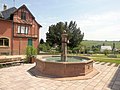
Fountain in front of the church


literature
- Le Patrimoine des Communes du Haut-Rhin. Flohic Editions, Volume 1, Paris 1998, ISBN 2-84234-036-1 , pp. 522-528.
proof
- ^ Entry in the Base Mérimée of the Ministry of Culture. Retrieved August 27, 2011 (French).
- ^ Entry in the Base Mérimée of the Ministry of Culture. Retrieved August 27, 2011 (French).
- ^ Entry in the Base Mérimée of the Ministry of Culture. Retrieved October 7, 2017 (French).
Web links
- Community presentation (French)