
Ranspach
| Ranspach | ||
|---|---|---|
.svg)
|
|
|
| region | Grand Est | |
| Department | Haut-Rhin | |
| Arrondissement | Thann-Guebwiller | |
| Canton | Cernay | |
| Community association | Vallée de Saint-Amarin | |
| Coordinates | 47 ° 53 ' N , 7 ° 1' E | |
| height | 409–1,260 m | |
| surface | 11.40 km 2 | |
| Residents | 819 (January 1, 2017) | |
| Population density | 72 inhabitants / km 2 | |
| Post Code | 68470 | |
| INSEE code | 68262 | |

Ranspach is a French commune with 819 inhabitants (as of January 1, 2017) in the Haut-Rhin department in the Grand Est region (until 2015 Alsace ). It belongs to the Arrondissement Thann-Guebwiller , the canton of Cernay and is a member of the municipal association Vallée de Saint-Amarin .
geography
The municipality of Ranspach is located in the Thur Valley in the Vosges between Thann and the Col de Bussang . The municipality is part of the Ballons des Vosges Regional Nature Park .
Population development
| year | 1962 | 1968 | 1975 | 1982 | 1990 | 1999 | 2007 | 2017 |
| Residents | 1084 | 964 | 885 | 844 | 907 | 892 | 853 | 819 |

Church of St. Anthony of Padua , built in 1856
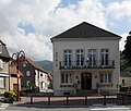
Mairie Ranspach


literature
- Le Patrimoine des Communes du Haut-Rhin. Flohic Editions, Volume 2, Paris 1998, ISBN 2-84234-036-1 , pp. 1061-1063.
Web links
Commons : Ranspach - collection of images, videos and audio files