
Mitzach
| Mitzach | ||
|---|---|---|
.svg)
|
|
|
| region | Grand Est | |
| Department | Haut-Rhin | |
| Arrondissement | Thann-Guebwiller | |
| Canton | Cernay | |
| Community association | Vallée de Saint-Amarin | |
| Coordinates | 47 ° 52 ' N , 7 ° 0' E | |
| height | 410–1,050 m | |
| surface | 6.41 km 2 | |
| Residents | 390 (January 1, 2017) | |
| Population density | 61 inhabitants / km 2 | |
| Post Code | 68470 | |
| INSEE code | 68211 | |

Mitzach is a French commune with 390 inhabitants (as of January 1, 2017) in the Haut-Rhin department in the Grand Est region (until 2015 Alsace ). It belongs to the Arrondissement of Thann-Guebwiller , the canton of Cernay and the Vallée de Saint-Amarin municipal association .
geography
The municipality of Mitzach is located in a side valley of the Thur in the Vosges at an altitude of 410 to 1050 meters above sea level.
history
From 1871 until the end of the First World War , Mitzach belonged to the German Empire as part of the realm of Alsace-Lorraine and was assigned to the district of Thann in the district of Upper Alsace .
Population development
| year | 1910 | 1962 | 1968 | 1975 | 1982 | 1990 | 1999 | 2007 | 2017 |
| Residents | 485 | 423 | 431 | 402 | 360 | 378 | 420 | 416 | 390 |
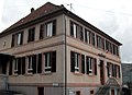
Mairie Mitzach

Saint Dominique Church


literature
- Le Patrimoine des Communes du Haut-Rhin. Flohic Editions, Volume 2, Paris 1998, ISBN 2-84234-036-1 , pp. 1051-1052.
Web links
Commons : Mitzach - collection of images, videos and audio files