
Uffholtz
| Uffholtz | ||
|---|---|---|
.svg)
|
|
|
| region | Grand Est | |
| Department | Haut-Rhin | |
| Arrondissement | Thann-Guebwiller | |
| Canton | Cernay | |
| Community association | Thann-Cernay | |
| Coordinates | 47 ° 49 ′ N , 7 ° 11 ′ E | |
| height | 267-1,120 m | |
| surface | 11.91 km 2 | |
| Residents | 1,795 (January 1, 2017) | |
| Population density | 151 inhabitants / km 2 | |
| Post Code | 68700 | |
| INSEE code | 68342 | |
| Website | http://www.uffholtz.fr/ | |
 Mairie Uffholtz |
||

Uffholtz ( German Uffholz ) is a French commune with 1795 inhabitants (as of January 1, 2017) in the Haut-Rhin department in the Grand Est region (until 2015 Alsace ). It belongs to the Arrondissement of Thann-Guebwiller and the canton of Cernay .
geography

Uffholtz in the Ballons des Vosges Regional Nature Park is located immediately north of Cernay and is part of the agglomeration . The municipality covers almost twelve square kilometers, the highest point in the municipality reaches 1120 meters. To the east of the village, an agricultural zone extends into the lower Thur Valley , the section of which already belongs to the Upper Rhine Plain.
The settlement borders closely on Cernay , but is about three kilometers away from the settlements in the neighboring village of Wattwiller . Two roads cross the village: the Alsatian wine route D 5 and the start of the Route des Crêtes D 431, which meanders over the Egelbachtal to the upper layers of the Vosges massif .
history
It was first mentioned in 823 as the property of Murbach Abbey . The place belonged to this monastery until the outbreak of the French Revolution . In the course of this, there were also anti-Semitic riots in Uffholtz in 1789 ; the houses of the Jews and their synagogue were looted.
From 1871 until the end of the First World War , Uffholtz belonged to the German Empire as part of the realm of Alsace-Lorraine and was assigned to the district of Thann in the district of Upper Alsace .
During the First World War, the site at the foot of the Hartmannsweiler Kopf and thus in an important battlefield was destroyed to 80 percent. Bunkers from this time are still preserved. In contrast to many other destroyed places, where reconstruction was waived due to soil contamination by gas and duds , Uffholtz was rebuilt in the same place.
| Population development | ||||||||
|---|---|---|---|---|---|---|---|---|
| year | 1910 | 1962 | 1968 | 1975 | 1982 | 1990 | 1999 | 2007 |
| Residents | 1,418 | 1,152 | 1,169 | 1,231 | 1,327 | 1,303 | 1,385 | 1,559 |
Culture and sights
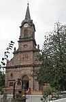
St. Erasmus Church
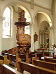
Wooden pulpit


Catholic Church
Due to its enormous size, the church of the village leaves a considerable impression. It is the reconstruction from 1924 of the church from 1825, which was destroyed in the First World War. The main facade and the bell tower are made of hewn red sandstone blocks and are decorated with decorative sculptures such as pilasters , balusters, borders and reliefs. The new baroque spire is a special feature of the place because there is no other tower of this type in the area. The main nave and the two side aisles of the interior design are under a single large gable roof .
The interior fittings are mainly characterized by their wood- carved furniture , in particular an impressive pulpit with a spiral staircase . Carved choir stalls and wood paneling frame the choir room . Two windows with colored glass decor pay tribute to the two patron saints of the church, Saint Erasmus and Saint Anthony . Other windows were damaged by the war events between October 1944 and February 1945 and were then replaced in 1957. The main altar was modeled on that of St Sulpice in Paris .

Shelter of remembrance
During the First World War, around 80 percent of Uffholtz was destroyed. The historic inn, a permanent house and its cellar, served the German military as a medical shelter ( shelter ) from 1916 because of its proximity to the front . The building is one of the few that survived the war. In order to keep memories of the war events alive, the house was renovated at great expense.
Since 2010, the museum is Abri-mémoire (shelter of remembrance) accommodated: In the basement, images and videos from the ski jump war shown in Alsace. On the upper floor there is a conference room and a library. The illustrative material available relates to the battles and events that took place in France at that time, especially on and around the Hartmannswillerkopf .
With its free access, the house should be a hospitable meeting place for village residents, but also for interested parties and historical researchers.
Other sights

- Antoniuskapelle : Located on a slope in the Egelbachtal not far from the vineyard , this chapel is a modest but significant landmark for Uffholtz. It was repaired at least twice - as a result of the damage caused by the First World War and again in 1958. According to legend, a hermit lived there, whose hermitage is said to have beenmentioned for the first time in 1264. The current building is the reconstruction from 1958 of a previous building that was destroyed in the First World War.
- Since 1993, the ascent to the Antonius Chapel has been organized once a year. On the Saturday before or after the holiday of the saint (January 17), the festival begins at 5 p.m. with a solemn service in the parish church, under the direction of a bishop and the participation of an invited band. After dark, the faithful then make a pilgrimage on foot to the chapel, accompanied by lights and torches. On site, the magical atmosphere makes people happy and singing. The festival continues late into the night with a feast.
- Herrenfluh Castle ruins : Herrenfluh Castle only existed for a short time: on a rock spur at a height of 858 m, it was built in the 13th century by Hans Nordwind to defend the property of Murbach Abbey. Foreign troops destroyed it around 1376. During the First World War, the ruins were completely destroyed by German missiles, as the French had set up an observation post nearby. Crumbled walls still bear witness to this medieval castle.
- Shepherd's hut, the so-called "Hirtehisla"
- Schaecher , road cross, or large wayside shrine on the roadside
- Plague cross
- Carp fountain
- Coat of arms of the Schauenburg
- Berghütte , a house for friends of nature on the Molkenrain
economy
In addition to agriculture, which is operated by three large farms, there are craft and industrial businesses. The industrial area extends between Thur and Landstrasse N 83. It consists of the following companies:
- DuPont de Nemours Satellite 2
- Book printer "Publi-H"
- Plasturgy SIFAT AERAULIQUE
- Long-distance transport FERAL
- Precision mechanics EMERSON (Fisher Rosemont Group)
- Tapestry animation
Community partnerships
Since 1977 there has been a partnership with the German village of Aufheim, which belongs to the city of Senden . There are also friendly relationships with the wine village of Hügelheim, part of the city of Müllheim on the German side of the Rhine.
literature
- Le Patrimoine des Communes du Haut-Rhin. Flohic Editions, Volume 1, Paris 1998, ISBN 2-84234-036-1 , pp. 159-166.
Web links
proof
- ^ Website Uffholtz - Histoire
- ↑ a b Register of municipalities in Germany 1900 - Thann district
- ↑ a b Isabell Michelberger: Hartmannsweilerkopf: Place of common remembrance . In: Südkurier of July 29, 2015
- ^ Website Uffholtz - Tourisme & Histoire
- ^ Website Uffholtz - Jumelage & Partenariat