
Malmerspach
| Malmerspach | ||
|---|---|---|
.svg)
|
|
|
| region | Grand Est | |
| Department | Haut-Rhin | |
| Arrondissement | Thann-Guebwiller | |
| Canton | Cernay | |
| Community association | Vallée de Saint-Amarin | |
| Coordinates | 47 ° 52 ' N , 7 ° 2' E | |
| height | 386-868 m | |
| surface | 2.66 km 2 | |
| Residents | 504 (January 1, 2017) | |
| Population density | 189 inhabitants / km 2 | |
| Post Code | 68550 | |
| INSEE code | 68199 | |

Malmerspach is a French commune with 504 inhabitants (as of January 1, 2017) in the Haut-Rhin department of the Grand Est region (until 2015 Alsace ). It belongs to the Arrondissement Thann-Guebwiller , the canton of Cernay and is a member of the municipal association Vallée de Saint-Amarin .
geography
The municipality of Malmerspach is located in the Thur Valley in the Vosges , about halfway between Thann and the Col de Bussang . The municipality is part of the Ballons des Vosges Regional Nature Park .
history
From 1871 until the end of the First World War , Malmerspach belonged to the German Empire as part of the realm of Alsace-Lorraine and was assigned to the district of Thann in the district of Upper Alsace .
Population development
| year | 1910 | 1962 | 1968 | 1975 | 1982 | 1990 | 1999 | 2007 | 2017 |
| Residents | 787 | 542 | 616 | 574 | 500 | 537 | 557 | 524 | 504 |
Saint-Joseph-Artisan twelve-sided church from 1969

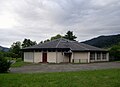
Mairie Malmerspach


literature
- Le Patrimoine des Communes du Haut-Rhin. Flohic Editions, Volume 2, Paris 1998, ISBN 2-84234-036-1 , p. 1050.