
Guewenheim
| Guewenheim | ||
|---|---|---|

|
|
|
| region | Grand Est | |
| Department | Haut-Rhin | |
| Arrondissement | Thann-Guebwiller | |
| Canton | Masevaux | |
| Community association | Vallée de la Doller et du Soultzbach | |
| Coordinates | 47 ° 45 ′ N , 7 ° 6 ′ E | |
| height | 309-420 m | |
| surface | 8.55 km 2 | |
| Residents | 1,302 (January 1, 2017) | |
| Population density | 152 inhabitants / km 2 | |
| Post Code | 68116 | |
| INSEE code | 68115 | |
 Mairie Guewenheim (from 2014) |
||

Guewenheim (German Gewenheim , Alsatian Gaiwana ) is a French commune with 1302 inhabitants (as of January 1, 2017) in the Haut-Rhin department in the Grand Est region (until 2015 Alsace ). It belongs to the Arrondissement Thann-Guebwiller , the canton Masevaux and is a member of the community association Vallée de la Doller et Soultzbach .
geography
The municipality of Guewenheim is located in the Doller Valley , about 16 kilometers west of Mulhouse .
Neighboring communities of Guewenheim are Roderen in the north, Michelbach in the northeast, Aspach-le-Bas in the east, Burnhaupt-le-Haut in the southeast, Soppe-le-Bas in the south, Soppe-le-Haut in the southwest, Sentheim in the west and Bourbach- le-Bas in the northwest.
history
From 1871 until the end of the First World War , Guewenheim belonged to the German Empire as part of the realm of Alsace-Lorraine and was assigned to the district of Thann in the district of Upper Alsace .
Population development
| year | 1910 | 1962 | 1968 | 1975 | 1982 | 1990 | 1999 | 2007 | 2017 |
|---|---|---|---|---|---|---|---|---|---|
| Residents | 879 | 798 | 778 | 833 | 877 | 1140 | 1176 | 1191 | 1302 |
Attractions
- St. Mauritius Church from 1828
- Notre Dame des Bouleaux chapel, mentioned as a pilgrim chapel in 1569 in an inventory of the Masmünster Abbey
- Cat museum
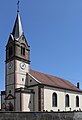
Southwest side of St. Mauritius

Interior view of St. Mauritius
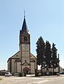
South side of St. Mauritius

former Mairie (until 2013)

Notre Dame des Bouleaux chapel


literature
- Le Patrimoine des Communes du Haut-Rhin. Flohic Editions, Volume 2, Paris 1998, ISBN 2-84234-036-1 , pp. 1268-1270.
Web links
- Guewenheim.com website of the village (French)