
Meyenheim
| Meyenheim | ||
|---|---|---|
.svg)
|
|
|
| region | Grand Est | |
| Department | Haut-Rhin | |
| Arrondissement | Thann-Guebwiller | |
| Canton | Ensisheim | |
| Community association | Center du Haut-Rhin | |
| Coordinates | 47 ° 55 ' N , 7 ° 21' E | |
| height | 206-213 m | |
| surface | 12.78 km 2 | |
| Residents | 1,480 (January 1, 2017) | |
| Population density | 116 inhabitants / km 2 | |
| Post Code | 68890 | |
| INSEE code | 68205 | |
 Mairie Meyenheim |
||

Meyenheim (German Meienheim ) is a French commune with 1480 inhabitants (January 1, 2017) in the Haut-Rhin department in the Grand Est region (until 2015 Alsace ). It belongs to the Arrondissement of Thann-Guebwiller and the canton of Ensisheim . Meyenheim is a garrison of the French army and is currently (2013) the "Régiment de marche du Tchad" - (Chad March Regiment). It uses the Dio quarter , the former Colmar-Meyenheim military airfield .
geography
The municipality of Meyenheim lies on both sides of the Ill , about halfway between Colmar and Mulhouse .
history
From 1871 until the end of the First World War , Meyenheim belonged to the German Empire as part of the realm of Alsace-Lorraine and was assigned to the Gebweiler district in the Upper Alsace district .
Population development
| year | 1910 | 1962 | 1968 | 1975 | 1982 | 1990 | 1999 | 2007 | 2017 |
| Residents | 591 | 888 | 1080 | 1041 | 1003 | 884 | 957 | 1217 | 1480 |
Attractions
- Church of St. Peter and Paul, rebuilt between 1802 and 1820 (parts of the tower from the 12th century), reconstructed in 1981
- Water tower ( Château d'Eau ) on the Alte Thur

Church of St. Peter and Paul 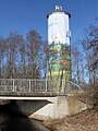
Water tower


literature
- Le Patrimoine des Communes du Haut-Rhin. Flohic Editions, Volume 1, Paris 1998, ISBN 2-84234-036-1 , pp. 361-363.
Web links
- Community presentation (French)