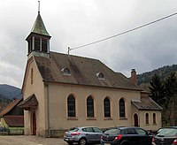
Storckensohn
| Storckensohn | ||
|---|---|---|

|
|
|
| region | Grand Est | |
| Department | Haut-Rhin | |
| Arrondissement | Thann-Guebwiller | |
| Canton | Cernay | |
| Community association | Vallée de Saint-Amarin | |
| Coordinates | 47 ° 53 ' N , 6 ° 57' E | |
| height | 470-1,220 m | |
| surface | 5.10 km 2 | |
| Residents | 207 (January 1, 2017) | |
| Population density | 41 inhabitants / km 2 | |
| Post Code | 68470 | |
| INSEE code | 68328 | |
Storckensohn (German Storkensauen ) is a French commune with 207 inhabitants (as of January 1, 2017) in the Haut-Rhin department in the Grand Est region (until 2015 Alsace ). It belongs to the Arrondissement Thann-Guebwiller , the canton of Cernay and is a member of the municipal association Vallée de Saint-Amarin .
geography
The municipality of Storckensohn is located in a side valley of the Thur in the Vosges near the Col de Bussang . The municipality is part of the Ballons des Vosges Regional Nature Park .
history
From 1871 until the end of the First World War , Storckensohn belonged to the German Empire as part of the realm of Alsace-Lorraine and was assigned to the district of Thann in the district of Upper Alsace .
Population development
| year | 1910 | 1962 | 1968 | 1975 | 1982 | 1990 | 1999 | 2007 | 2017 |
| Residents | 353 | 209 | 240 | 229 | 248 | 239 | 228 | 253 | 207 |
Attractions
In 1732 a water-powered mill was built in Storckensohn, which still exists today.

Mairie and school buildings
|
literature
- Le Patrimoine des Communes du Haut-Rhin. Flohic Editions, Volume 2, Paris 1998, ISBN 2-84234-036-1 , pp. 1069-1070.
Web links
Individual evidence
- ↑ Portal to the department ( page no longer available , search in web archives ) Info: The link was automatically marked as defective. Please check the link according to the instructions and then remove this notice.
- ↑ Municipal directory Germany 1900 - District Thann


