
Pfaffenheim
| Pfaffenheim | ||
|---|---|---|
.svg)
|
|
|
| region | Grand Est | |
| Department | Haut-Rhin | |
| Arrondissement | Thann-Guebwiller | |
| Canton | Wintzenheim | |
| Community association | Pays de Rouffach, Vignobles et Châteaux | |
| Coordinates | 47 ° 59 ′ N , 7 ° 17 ′ E | |
| height | 196-843 m | |
| surface | 14.57 km 2 | |
| Residents | 1,457 (January 1, 2017) | |
| Population density | 100 inhabitants / km 2 | |
| Post Code | 68250 | |
| INSEE code | 68255 | |

Pfaffenheim an der Elsässer Weinstrasse is a French commune with 1,457 inhabitants (as of January 1, 2017) in the Haut-Rhin department in the Grand Est region (until 2015 Alsace ). She is a member of the association of the Pays de Rouffach, Vignobles et Châteaux .
geography
Pfaffenheim is located in the Upper Rhine Plain on the eastern edge of the Vosges at 200 meters above sea level, about 14 km southwest of Colmar and about 32 km north of Mulhouse . The leek flows east of the village . The next larger town is Rouffach to the south. The municipality covers 14.57 km². The highest point of the place reaches a height of 843 m. In the west is the Forêt communale de Pfaffenheim , which forms a unit with the Forêt communale de Westhalten . The municipality is part of the Ballons des Vosges Regional Nature Park .
history
From 1871 until the end of the First World War , Pfaffenheim belonged to the German Empire as part of the realm of Alsace-Lorraine and was assigned to the Gebweiler district in the Upper Alsace district .
Population development
| year | 1910 | 1962 | 1968 | 1975 | 1982 | 1990 | 1999 | 2006 |
| Residents | 1,325 | 1,031 | 1.007 | 1.103 | 1,087 | 1,130 | 1,186 | 1,305 |
Attractions
- The Church of St. Martin was originally built around 1235. The choir in the Romanesque-Gothic transition style has been preserved from this period . The nave was built in 1893 on the foundations of a dilapidated previous building, the church tower dates from the 20th century. In the church there is an organ by the French organ builders Joseph and Claude-Ignace Callinet from the 19th century.
- The Notre-Dame-du-Schauenberg pilgrimage chapel is a Marian pilgrimage site , it is located about five kilometers northwest of the town in the forest with a good view of the Upper Rhine Plain. The chapel was built in 1440 and expanded in 1515.
- Autel of the Druid

town hall

St. Martin Church
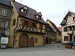
Half-timbered houses
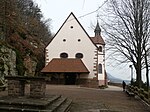
Notre-Dame-du-Schauenberg


Economy and Infrastructure
Viticulture plays a prominent role in Pfaffenheim. Large areas are planted with vines. The place is one of the 33 communities in Upper Alsace that are involved in the Alsace Grand Cru (together with Westhalten to the south, the Steinert location ). An educational wine trail - according to the municipality the oldest in Alsace - provides information on this topic on a two-hour tour. The place is also known for its chestnuts from the surrounding forests.
The four-lane department road D 83 and a railway line of the SNCF run east of the city . The next train station is in Rouffach.
Community partnerships
A partnership has existed with Gronau , a district of the German city of Bensheim in Hesse , since 1994.
literature
- Le Patrimoine des Communes du Haut-Rhin. Flohic Editions, Volume 2, Paris 1998, ISBN 2-84234-036-1 , pp. 1011-1014.