
Bourbach-le-Haut
| Bourbach-le-Haut | ||
|---|---|---|
.svg)
|
|
|
| region | Grand Est | |
| Department | Haut-Rhin | |
| Arrondissement | Thann-Guebwiller | |
| Canton | Cernay | |
| Community association | Thann-Cernay | |
| Coordinates | 47 ° 48 ' N , 7 ° 2' E | |
| height | 439-1,183 m | |
| surface | 6.86 km 2 | |
| Residents | 420 (January 1, 2017) | |
| Population density | 61 inhabitants / km 2 | |
| Post Code | 68290 | |
| INSEE code | 68046 | |

Bourbach-le-Haut (German Oberburbach ) is a French commune with 420 inhabitants (as of January 1, 2017) in the Haut-Rhin department in the Grand Est region (until 2015 Alsace ).
geography
The municipality is located in the Vosges on the pass road to the Col du Hundsruck between Masevaux and Bitschwiller-lès-Thann in the Ballons des Vosges Regional Nature Park . The surrounding area is largely forested.
history
From 1871 until the end of the First World War , Bourbach-le-Haut belonged to the German Empire as part of the realm of Alsace-Lorraine and was assigned to the district of Thann in the district of Upper Alsace .
Population development
| 1910 | 1962 | 1968 | 1975 | 1982 | 1990 | 1999 | 2007 |
|---|---|---|---|---|---|---|---|
| 487 | 150 | 183 | 187 | 231 | 257 | 324 | 424 |
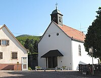
Saint-Michel church

Town hall and school building


literature
- Le Patrimoine des Communes du Haut-Rhin. Flohic Editions, Volume 1, Paris 1998, ISBN 2-84234-036-1 , p. 727.
Web links
Commons : Bourbach-le-Haut - Collection of images, videos and audio files
- Bourbach-le-Bas at the Communauté de communes du Pays de Thann (French)