
Lautenbachzell
| Lautenbachzell | ||
|---|---|---|

|
|
|
| region | Grand Est | |
| Department | Haut-Rhin | |
| Arrondissement | Thann-Guebwiller | |
| Canton | Guebwiller | |
| Community association | Region of Guebwiller | |
| Coordinates | 47 ° 56 ' N , 7 ° 9' E | |
| height | 368-1,420 m | |
| surface | 23.14 km 2 | |
| Residents | 955 (January 1, 2017) | |
| Population density | 41 inhabitants / km 2 | |
| Post Code | 68610 | |
| INSEE code | 68178 | |
 Mairie and school in Lautenbachzell |
||

Lautenbachzell (also: Lautenbach-Zell ) is a French commune with 955 inhabitants (as of January 1, 2017) in the Haut-Rhin department in the Grand Est region (until 2015 Alsace ). It is a member of the Communauté de communes de la Région de Guebwiller and is located in the Ballons des Vosges Regional Nature Park .
geography
The community is located in the valley of the Leek near the Großer Belchen (fr: Grand Ballon ). The districts of Sengern, Geffenthal, Haul, Muhlrain, Traenck, Felsenbach, Schutzle, Güstiberg and Brestenberg belong to the municipality . The neighboring municipality to the east is Lautenbach , separated by the river Lauch. The municipality of Linthal is located in a northern side valley at the height of Lautenbachzell .
history
From 1871 until the end of the First World War , Lautenbachzell belonged to the German Empire as part of the realm of Alsace-Lorraine and was assigned to the Gebweiler district in the Upper Alsace district .
Population development
| year | 1910 | 1962 | 1968 | 1975 | 1982 | 1990 | 1999 | 2007 | 2017 |
| Residents | 1,453 | 957 | 977 | 935 | 861 | 912 | 935 | 1017 | 955 |

The townscape of Lautenbachzell, the town hall on the left
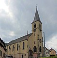
Church of St. Nikolaus in the district of Sengern


See also
literature
- Le Patrimoine des Communes du Haut-Rhin. Flohic Editions, Volume 1, Paris 1998, ISBN 2-84234-036-1 , pp. 510-514.