
Linthal (Haut-Rhin)
| Linthal | ||
|---|---|---|

|
|
|
| region | Grand Est | |
| Department | Haut-Rhin | |
| Arrondissement | Thann-Guebwiller | |
| Canton | Guebwiller | |
| Community association | Region of Guebwiller | |
| Coordinates | 47 ° 57 ' N , 7 ° 8' E | |
| height | 429-1,320 m | |
| surface | 20.84 km 2 | |
| Residents | 599 (January 1, 2017) | |
| Population density | 29 inhabitants / km 2 | |
| Post Code | 68610 | |
| INSEE code | 68188 | |

Linthal is a French commune with 599 inhabitants (as of January 1, 2017) in the Haut-Rhin département in the Grand Est region (until 2015 Alsace ). She is a member of the Région de Guebwiller municipal association .
geography
The municipality is located in the southern Vosges , in a northern side valley of the Lauchtal , in the Ballons des Vosges Regional Nature Park . The closest neighboring municipality is Lautenbachzell , located to the south .
history
From 1871 until the end of the First World War , Linthal belonged to the German Empire as part of the realm of Alsace-Lorraine and was assigned to the Gebweiler district in the Upper Alsace district .
| year | 1910 | 1962 | 1968 | 1975 | 1982 | 1990 | 1999 | 2006 | 2017 |
|---|---|---|---|---|---|---|---|---|---|
| Residents | 1003 | 613 | 640 | 548 | 523 | 512 | 575 | 607 | 599 |

Linthal from the north
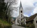
Sainte-Marie-Madeleine church
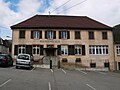
Town hall and school building


See also
literature
- Le Patrimoine des Communes du Haut-Rhin. Flohic Editions, Volume 1, Paris 1998, ISBN 2-84234-036-1 , pp. 515-517.
Web links
Commons : Linthal - collection of images, videos and audio files