
Oderen
| Oderen | ||
|---|---|---|
.svg)
|
|
|
| region | Grand Est | |
| Department | Haut-Rhin | |
| Arrondissement | Thann-Guebwiller | |
| Canton | Cernay | |
| Community association | Vallée de Saint-Amarin | |
| Coordinates | 47 ° 55 ' N , 6 ° 59' E | |
| height | 445-1,264 m | |
| surface | 19.12 km 2 | |
| Residents | 1,268 (January 1, 2017) | |
| Population density | 66 inhabitants / km 2 | |
| Post Code | 68830 | |
| INSEE code | 68247 | |
 View of the Thur Valley in Oderen |
||

Oderen (German Odern ) is a French commune with 1268 inhabitants (as of January 1, 2017) in the Haut-Rhin department in the Grand Est region (until 2015 Alsace ). It belongs to the Arrondissement of Thann-Guebwiller , the canton of Cernay and the Vallée de Saint-Amarin municipality .
geography
The municipality in the Ballons des Vosges Regional Nature Park is located in the valley of the Upper Thur , a few kilometers from the 1200 m high Drumont on the Vosges ridge . The 884 m high Col d'Oderen named after the place leads above Kruth over the ridge to Ventron in Lorraine .
Population development
| year | 1962 | 1968 | 1975 | 1982 | 1990 | 1999 | 2007 | 2017 |
| Residents | 1182 | 1254 | 1241 | 1331 | 1340 | 1318 | 1320 | 1268 |
Attractions
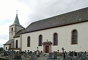
- St. Nikolaus mountain church with a Gothic bell tower from 1771, built on a rocky promontory
- Maria Hilf pilgrimage chapel ( Notre-Dame-du-Bon-Secours ) from 1893

Mairie Oderen
- St. Nicholas Mountain Church


- Pilgrimage chapel Maria Hilf


literature
- Le Patrimoine des Communes du Haut-Rhin. Flohic Editions, Volume 2, Paris 1998, ISBN 2-84234-036-1 , pp. 1058-1061.
Web links
Commons : Oderen - collection of images, videos and audio files