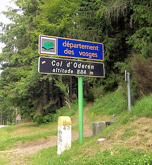
Col d'Oderen
| Col d'Oderen | |||
|---|---|---|---|
|
Pass height |
|||
| Compass direction | west | east | |
| Pass height | 884 m | ||
| Department | Vosges | Haut-Rhin | |
| Watershed | Ventron, Moselotte , Moselle | Thur , Ill | |
| Valley locations | Ventron | Kruth | |
| expansion | Pass road | ||
| Lock | Heavy truck | ||
| Mountains | Vosges | ||
| Map (Haut-Rhin) | |||
|
|
|||
| Coordinates | 47 ° 55 '22 " N , 6 ° 55' 2" E | ||
The Col d'Oderen ( Ger . Odernpass ) is a 884 m high pass in the Vosges .
The pass is four kilometers south of the 1202 meter high Grand Ventron and 2.5 kilometers north of the 1223 m high Drumont ( Trumenkopf ) between the communities of Ventron (lying to the west) and Kruth in the east. The border between the Département Vosges and the Département Haut-Rhin runs immediately to the west of the pass , the pass itself is part of the municipality of Fellering . The road leads over the pass from Fellering via Oderen and Kruth to Cornimont or Saulxures-sur-Moselotte .
The pass road was expanded during the First World War for strategic reasons. Due to the driving ban for heavy trucks and the proximity of the heavily frequented Büssingpass just a few kilometers south, the Odernpass has no supra-regional importance as a traffic axis. The well-developed road is appreciated by cyclists and motorcyclists in the warmer seasons.
The Ventron rises on the west side of the pass and drains over the Moselotte to the Moselle .


