Ventron
| Ventron | ||
|---|---|---|

|
|
|
| region | Grand Est | |
| Department | Vosges | |
| Arrondissement | Saint-Dié-des-Vosges | |
| Canton | La Bresse | |
| Community association | Hautes Vosges | |
| Coordinates | 47 ° 56 ' N , 6 ° 52' E | |
| height | 570-1,202 m | |
| surface | 24.97 km 2 | |
| Residents | 838 (January 1, 2017) | |
| Population density | 34 inhabitants / km 2 | |
| Post Code | 88310 | |
| INSEE code | 88500 | |
 Location of Ventron in the Vosges department |
||
Ventron (dt. Winterung ) is a French commune with 838 inhabitants (as of January 1, 2017) in the Vosges department in the Grand Est region (until 2015 Lorraine ). It belongs to the Arrondissement of Saint-Dié-des-Vosges and the Hautes Vosges municipal association .
geography
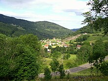
The winter sports community of Ventron is located in the Vosges , 30 kilometers from Remiremont and 45 kilometers from Mulhouse .
The municipal area of Ventron is identical with the catchment area of the Moselotte tributary Ventron , including its tributaries Rupt du Moulin and Ruisseau des Vinterges, except for the estuary . The three flowing waters have their source on the Vosges main ridge, which also forms the eastern municipal boundary and the border with the former Alsace region . In the northeastern corner of the community area rises the 1202 meter high Grand Ventron , which can be reached from Ventron via a road. In the east, with the 884 meter high Col d'Oderen, there is a road crossing into the Alsatian Thur Valley . The 957 meter high saddle of the Col du Page in the south leads to Bussang in the headwaters of the Moselle and is reserved for pedestrians and cyclists.
The valley floor in Ventron, which is around 600 meters high, is not suitable for arable farming, so pasture farming predominates. About two thirds of the almost 25 km² large municipal area are forested: in the east the closed wooded area of the Forêt du Rupt Furchu , in the south forests interrupted by numerous ski slopes. characterized by residential and commercial areas, little space remains for agricultural use.
Ventron has a very loose development, many holiday homes are scattered on the slopes. A somewhat denser settlement core can only be seen around the church. The district of Les Malcostes, which borders Cornimont-Travexin in the west, belongs to Ventron .
Neighboring communities of Ventron are Cornimont in the west and north, Kruth in the northeast, Fellering in the east, Bussang in the south and Le Ménil in the southwest.
history
It is believed that the area around Ventron was settled by Alsatians or Swiss in the 11th century. Uberwinter , 1579 Wynterau appeared as the name of the collection of huts . By 1617 at the latest, people spoke of Ventron, which belonged to the Bishop of Toul, Jean des Porcelets de Maillane (1581-1624).
Textile industry
At the beginning of the 19th century the textile industry came from Alsace to the Lorraine side of the Vosges. Until then, the families lived on a self-sufficient basis. After the first spinning mill was founded in nearby Saulxures-sur-Moselotte in 1825, the first mechanical looms came to Ventron in 1840. For twenty years the community had 288 jobs in four factories. The reason for choosing the location in the Vosges valleys was the existing water power of the mountain rivers, which initially drove the mechanical looms before the steam engines took the place of the water wheel.
The weaving mills that sold the fabric as Grand Ventron remained successful until the beginning of the Second World War. From the 1950s onwards, the textile industry began to decline in the entire Vosges region.
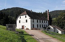
The textile museum Ventron was set up in a factory founded in 1855 and closed in 1952. After extensive restoration, the drive shafts, gears, pulleys and belts can be put into operation for viewing.
Population development
| 1962 | 1968 | 1975 | 1982 | 1990 | 1999 | 2007 | 2017 | ||
| 924 | 970 | 915 | 970 | 900 | 979 | 928 | 838 | ||
| Sources: Cassini and INSEE | |||||||||
Attractions
- Saint-Claude Church, built in 1841
- Eremitenkapelle Frère-Joseph (Brother Joseph) from 1757
- Museum of the textile industry
Economy and Infrastructure
Agriculture today only plays a subordinate role in the upper Vosges. Ten farms are still located in Ventron (walnut cultivation, dairy farming, horse and cattle breeding, sheep and goat farming). After the decline of the textile industry, Ventron increasingly turned to tourism. The high-altitude health resort has now been developed for tourism through hotels, guest houses, holiday homes and youth hostels. A tourist office ( Office de tourisme ) in town coordinates the activities. The ski area around the chapel of Brother Josef ( Ermitage Frère Joseph ), a hermit who lived there in seclusion for 30 years and died in 1784, is known nationwide. From a hotel near the chapel, ski lifts and a chair lift lead to the ski slopes. In addition, 16 kilometers of cross-country trails are groomed in winter. A school for paragliders opens in Ventron in summer.
Ventron can be reached from Route nationale 66 ( European route 512 ) ( Épinal - Mulhouse ) from Le Thillot via Le Ménil or from Fellering via the Col d'Oderen . There are other road connections to Remiremont and Gérardmer .
supporting documents
- ↑ Textile Museum (French)
- ↑ Ventron on cassini.ehess.fr
- ↑ Ventron on insee.fr
- ↑ Farms on annuaire-mairie.fr (French)


