Bertrimoutier
| Bertrimoutier | ||
|---|---|---|
|
|
||
| region | Grand Est | |
| Department | Vosges | |
| Arrondissement | Saint-Dié-des-Vosges | |
| Canton | Saint-Dié-des-Vosges-2 | |
| Community association | Saint-Dié-des-Vosges | |
| Coordinates | 48 ° 16 ' N , 7 ° 3' E | |
| height | 373-596 m | |
| surface | 3.72 km 2 | |
| Residents | 310 (January 1, 2017) | |
| Population density | 83 inhabitants / km 2 | |
| Post Code | 88520 | |
| INSEE code | 88054 | |
| Website | www.bertrimoutier.fr | |
 Location of Bertrimoutier in the Vosges department |
||
Bertrimoutier is a French commune with 310 inhabitants (as of January 1, 2017) in the Vosges department in the Grand Est region (until 2015 Lorraine ). It belongs to the arrondissement of Saint-Dié-des-Vosges and the canton of Saint-Dié-des-Vosges-2 .
geography
Bertrimoutier is located on a plateau, the height of which varies between 350 and 560 meters. The village covers an area of 367 hectares, 27 of which are municipal forest. The main artery is Route départementale 23 . The center of the village is essentially grouped around the church, around which the other municipal facilities are located. A tributary of the Fave , the Blanc Rupt, limits the community in the south. The districts of Bonipaire, Layegoutte, Le Giron, Renigoutte, Les Censes and Bellevue also belong to the municipality . The next larger city is Saint-Dié-des-Vosges about 15 kilometers away.
Neighboring communities of Bertrimoutier are Combrimont in the north-east and east, Wisembach in the south-east, Ban-de-Laveline in the south, Raves in the south-west and west and Neuvillers-sur-Fave in the north-west.
history
Bertrimoutier was founded around 1171 by Bertherus, who founded a monastery there (French monastère ) as an offshoot of the Saint-Dié monastery. In 1331 the village was almost completely destroyed by the troops of the Baron von Lorraine during a campaign against the Baron von Bar. After an intercession by the monks with King Philip VI. the monastery was awarded a compensation of 750 pounds.
The next documentary mention is in 1553 in a registration document of the tithe , in which the number of inhabitants (without monks) was put at 12.
In 1848 the commune already included the villages of Combrimont, Bonipaire, Layegoutte, Lesseux, Frapelle, Neuvillers, Pair, Grandrupt and Raves and thus 156 inhabitants. By the Franco-Prussian War in 1870, the population increased to 328. The highest population level was reached in 1886, when 375 people lived in the municipality.
Population development
| year | 1962 | 1968 | 1975 | 1982 | 1990 | 1999 | 2007 |
| Residents | 211 | 231 | 265 | 346 | 341 | 336 | 374 |
Culture and sights
church
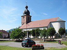
The church of Saint-Jacques-le-Majeur, (German: St. Jakob the Elder ) is an onion-dome church that was probably built in the 17th century . The church organ was built by Auguste Chaxel.
Military cemetery
The military cemetery of Bertrimoutier is a 7,699 graves memorial for the dead of the First World War. It was commissioned by the French Home Office in 1920. It contains the remains of a total of twelve temporary soldiers' cemeteries that were excavated at the front between 1915 and 1918. What is remarkable is the merging of soldiers from both nations, who, although separated, rest in the same cemetery.
International contacts
Adult education
An institute for vocational adult education is located in Bertrimoutier and has course participants from Germany, Austria, North Schleswig, South Tyrol and Switzerland. It is certified for learning partnerships of the EU exchange program GRUNDTVIG and is also a French partner institute of the Academy for Music Education and Media Education in Remscheid (North Rhine-Westphalia).


