
Celles-sur-Plaine
| Celles-sur-Plaine | ||
|---|---|---|

|
|
|
| region | Grand Est | |
| Department | Vosges | |
| Arrondissement | Saint-Dié-des-Vosges | |
| Canton | Raon-l'Étape | |
| Community association | Saint-Dié-des-Vosges | |
| Coordinates | 48 ° 27 ' N , 6 ° 57' E | |
| height | 300-831 m | |
| surface | 20.09 km 2 | |
| Residents | 821 (January 1, 2017) | |
| Population density | 41 inhabitants / km 2 | |
| Post Code | 88110 | |
| INSEE code | 88082 | |
 Town hall of Celles-sur-Plaine |
||

Celles-sur-Plaine is a French commune with 821 inhabitants (as of January 1, 2017) in the Vosges department in the Grand Est region (until 2015 Lorraine ). It belongs to the canton of Raon-l'Étape in the arrondissement of Saint-Dié-des-Vosges .
geography

Celles-sur-Plaine is a municipality in the Vallée de la Plaine in the Vosges Mountains . It is a settlement on the Meurthe tributary, the Plaine, flanked by the Forêt domaniale des élieux and the Forêt domaniale de Celles . The river forms the border with the Meurthe-et-Moselle department . The municipality is connected to the national road network by the 392a department road. To the southwest of the town center is the Lac de Celles-sur-Plaine , a reservoir created in 1983. There are two prominent elevations in the municipality: the Pain de Sucre (671 m) and the Tête du Coquin (837 m).
history
Celles-sur-Plaine belonged to the County of Salm from 1594 and to the Duchy of Lorraine and the Principality of Salm from 1710 to 1790. Then the settlement passed to the Saint-Dié district.
In 1950, the Nicolas Bourbaki group met in Celles-sur-Plaine .
The Lac de Celles-sur-Plaine was created in 1983 in connection with the Lac de Pierre-Percée reservoir . It serves to regulate the Moselle and thus to cool the Cattenom nuclear power plant .
Population development
| year | 1962 | 1968 | 1975 | 1982 | 1990 | 1999 | 2007 | 2016 |
| Residents | 900 | 961 | 1,030 | 934 | 843 | 840 | 851 | 847 |
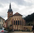
Church of St. Peter and Paul

typical row of houses in Lorraine
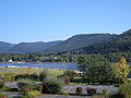
Lac de la Plaine


