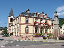
Plainfaing
| Plainfaing | ||
|---|---|---|

|
|
|
| region | Grand Est | |
| Department | Vosges | |
| Arrondissement | Saint-Dié-des-Vosges | |
| Canton | Gerardmer | |
| Community association | Saint-Dié-des-Vosges | |
| Coordinates | 48 ° 10 ′ N , 7 ° 1 ′ E | |
| height | 518-1,302 m | |
| surface | 38.56 km 2 | |
| Residents | 1,676 (January 1, 2017) | |
| Population density | 43 inhabitants / km 2 | |
| Post Code | 88230 | |
| INSEE code | 88349 | |
| Website | http://www.plainfaing.com/ | |
 Location of the commune of Plainfaing in the Vosges department |
||
Plainfaing is a French commune with 1676 inhabitants (January 1, 2017) in the Vosges department in the Grand Est region (until 2015 Lorraine ). It belongs to the Arrondissement of Saint-Dié-des-Vosges and the municipality of Saint-Dié-des-Vosges .
geography
Plainfaing is located at the foot of the Col du Bonhomme on the upper Meurthe , 17 kilometers southeast of Saint-Dié-des-Vosges , the capital ( Chef-lieu ) of the arrondissement of the same name. The eastern municipal boundary runs on the ridge of the Vosges and also forms the border with the Haut-Rhin department . The Meurthe flows through the municipality from south-east to north-west and takes in several small mountain streams ( Ruisseau de Cascade, Ruisseau du Louschbach ). The highest elevation in the municipality of Plainfaing is the 1302 m high Gazon du Faing , several other mountains reach the 1000 m mark, including the Haut de Steige (1088 m) west of the Meurthe. An approx. 4 km² area in the southwest of the municipality is over 1100 meters above sea level and is not forested, here is the Gazon du Faing Tanet nature reserve, established in 1988 with the flora typical of high moors.
Two thirds of the 38.56 km² municipal area of Plainfaings consists of forests ( Forêt domaniale de la Haute-Meurthe, Forêt communale de Fraize, Bois du Lesseux ), which extend to the ridge of the Vosges. In the lower lying areas there is pastureland, an economic grain cultivation is no longer possible due to the altitude.
Plainfaing includes the districts of Barançon, Habeaurupt, La Hardalle and Le Rudlin .
Neighboring municipalities of Plainfaing are Fraize in the north, Le Bonhomme , Orbey and Soultzeren in the east and south-east ( department Haut-Rhin ), Le Valtin in the south and Ban-sur-Meurthe-Clefcy in the west.
history

Plainfaing (earlier spellings: Pleinfaing, Pleinfin ) originally belonged to the Fraize ban .
In the 16th century, a canon of the cathedral in Saint-Dié-des-Vosges, who was born in Plainfaing, created the first chapel that no longer exists today. In 1782 the parish of Plainfaing was founded with the newly built Saint-Nicolas church, to which the surrounding hamlets belonged.
Fraize and Plainfaing were created in 1783 from the Fraize spell, which included many scattered hamlets .
As in other Vosges valleys, the textile industry found its way into Plainfaing from the middle of the 19th century. The founder is Nicolas Geliot (1805–1873), industrialist and mayor of Plainfaing. In 1905 the highest number of inhabitants to date was registered with 5300. In 1970 a long era came to an end with the closure of all textile factories, which resulted in high unemployment and emigration. In the following decades a new economic structure could only be built up gradually.
Today almost all industrial fallow land has been cleared, the drinking water network has been renewed, and the post office and town hall have been renovated.
Population development
| year | 1962 | 1968 | 1975 | 1982 | 1990 | 1999 | 2007 | 2017 | |
| Residents | 2519 | 2803 | 2402 | 2235 | 1948 | 1764 | 1819 | 1676 | |
| Sources: Cassini and INSEE | |||||||||
Attractions
- Church Saint-Nicolas
- Chapel Saint-Jean-Baptiste in the district Habaurupt
Economy and Infrastructure
Agriculture today only plays a subordinate role in the upper Meurthetal. There are 15 farms in the community (potato cultivation, dairy farming, horse, cattle, sheep and goat breeding). Due to the abundance of forests in the upper Vosges, forestry has a long tradition. In Plainfaing today there are smaller companies whose products include furniture, drums and metal paints.
education
In addition to a kindergarten, there are two primary schools in Plainfaing, the École Primaire du Center and the École de la Truche , and the Collège de la Haute-Meurthe is located in the nearby small town of Fraize .
Transport links
Plainfaing is on Route nationale 415 , which runs from Saint-Dié-des-Vosges via the nearby Col du Bonhomme and Colmar to Breisach am Rhein . From Plainfaing, Départementsstraße 23 leads upstream along the Meurthe to the foot of the Col de la Schlucht .
Personalities
- Maurice Jacquel (1929-2004), wrestler

