Luvigny
| Luvigny | ||
|---|---|---|

|
|
|
| region | Grand Est | |
| Department | Vosges | |
| Arrondissement | Saint-Dié-des-Vosges | |
| Canton | Raon-l'Étape | |
| Community association | Saint-Dié-des-Vosges | |
| Coordinates | 48 ° 30 ' N , 7 ° 4' E | |
| height | 375-810 m | |
| surface | 3.94 km 2 | |
| Residents | 112 (January 1, 2017) | |
| Population density | 28 inhabitants / km 2 | |
| Post Code | 88110 | |
| INSEE code | 88277 | |
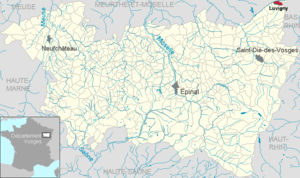
 Location of Luvigny in the Vosges department |
||
Luvigny is a French commune with 112 inhabitants (as of January 1, 2017) in the Vosges department in the Grand Est region ( Lorraine until 2015 ). It belongs to the canton of Raon-l'Étape in the arrondissement of Saint-Dié-des-Vosges .
geography
The commune of Luvigny is located on the Plaine near the Vosges ridge , which marks the border with the Bas-Rhin department (former Alsace region ).
Neighboring municipalities of Luvigny are Raon-sur-Plaine in the northeast, Grandfontaine in the east, Vexaincourt in the south and Bionville in the west.
history
It was first mentioned in 1656, when the settlement belonged to the Principality of Salm. The district of the municipality covers two thirds of the Bois Sauvages , which it shares with Allarmont . Translated, this means something like wild caught forest . The river la Plaine forms the north-western municipal boundary and at the same time the departmental boundary.
Population development
| year | 1962 | 1968 | 1975 | 1982 | 1990 | 1999 | 2012 |
| Residents | 121 | 126 | 105 | 123 | 88 | 94 | 110 |
Attractions
- Church Saint-Barthélémy , built in 1779

