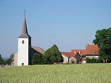
Champdray
| Champdray | ||
|---|---|---|
|
|
||
| region | Grand Est | |
| Department | Vosges | |
| Arrondissement | Saint-Dié-des-Vosges | |
| Canton | Bruyères | |
| Community association | Hautes Vosges | |
| Coordinates | 48 ° 8 ′ N , 6 ° 45 ′ E | |
| height | 589-809 m | |
| surface | 9.49 km 2 | |
| Residents | 179 (January 1, 2017) | |
| Population density | 19 inhabitants / km 2 | |
| Post Code | 88640 | |
| INSEE code | 88085 | |
 Town hall and school building |
||
Champdray is a French commune with 179 inhabitants (January 1, 2017) in the Vosges department in the Grand Est region ( Lorraine until 2015 ). It belongs to the arrondissement of Saint-Dié-des-Vosges .
geography
The municipality of Champdray is located in the Vosges , about 13 kilometers northwest of the city of Gérardmer and about 25 kilometers east of Épinal .
The 9.49 km² municipal area of Champdray extends on the heights west of the upper valley of the Vologne . About half of the municipal area is forested, especially the locations over 700 meters in the north and west. At over 550 meters above sea level in the valley, there is hardly any economic arable farming, which is why pastures dominate the valleys and on the lower slopes. The highest point in the municipality is the Spiémont at 809 meters above sea level. In addition to the main village of Champdray with Mairie and church, the community consists of further hamlets and individual farms. The hamlets include Donmeix, Sous Spiémont, Champ de Laxet, Le Passage and Les Spaxes de Champdray . Neighboring communities of Champdray are Jussarupt in the north, Granges-Aumontzey in the northeast and east, Liézey in the southeast, Rehaupal in the southwest and Laveline-du-Houx in the west.
history
The parish in Champdray was long a branch of the church in Champ-le-Duc , eight kilometers to the north , before the parish of Notre-Dame de Champdray was founded with its own church in 1669. Until the construction of the church in Rehaupal in the 19th century, its residents were parish in Champdray. Ecclesiastically Champdray belonged to the deanery of Remiremont in the diocese of Toul until the diocese of Saint-Die was founded in 1777.
Population development
| 1962 | 1968 | 1975 | 1982 | 1990 | 1999 | 2005 | 2014 |
| 253 | 196 | 151 | 159 | 160 | 184 | 165 | 171 |
In 1831 Champdray had 1,093 inhabitants.
Attractions
- Church of the Nativity of the Virgin Mary ( Église de la Nativité-de-Notre-Dame )
- several hall crosses
- Water tower
Economy and Infrastructure
Champdray is now a tourist town with guest houses and holiday homes. The municipality owes this development to its location near the waterfalls of Tendon and the Lac de Gérardmer as well as the convenient transport links to the city of Gérardmer .
supporting documents
- ↑ Champdray on vosges-archives.com ( page no longer available , search in web archives ) Info: The link was automatically marked as defective. Please check the link according to the instructions and then remove this notice. (French)
- ↑ Champdray on cassini.ehess.fr
Web links
- Community presentation (French)


