Etival Clairefontaine
| Etival Clairefontaine | ||
|---|---|---|

|
|
|
| region | Grand Est | |
| Department | Vosges | |
| Arrondissement | Saint-Dié-des-Vosges | |
| Canton | Raon-l'Étape | |
| Community association | Saint-Dié-des-Vosges | |
| Coordinates | 48 ° 22 ′ N , 6 ° 51 ′ E | |
| height | 285-591 m | |
| surface | 27.12 km 2 | |
| Residents | 2,616 (January 1, 2017) | |
| Population density | 96 inhabitants / km 2 | |
| Post Code | 88480 | |
| INSEE code | 88165 | |
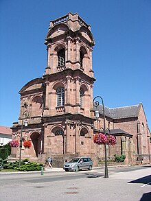
 View of Etival |
||
Étival-Clairefontaine is a French commune with 2,616 inhabitants (as of January 1, 2017) in the Vosges department in the Grand Est region ( Lorraine until 2015 ). It belongs to the arrondissement of Saint-Dié-des-Vosges and the canton of Raon-l'Étape .
geography
The municipality of Étival-Clairefontaine is located in the Meurthe valley in the Vosges , about ten kilometers northwest of Saint-Dié-des-Vosges .
Neighboring municipalities of Étival-Clairefontaine are Raon-l'Étape in the north, Moyenmoutier in the east, La Voivre in the southeast, Nompatelize in the south, Saint-Remy in the southwest, Saint-Benoît-la-Chipotte in the west and Sainte-Barbe in the northwest.
Population development
| year | 1962 | 1968 | 1975 | 1982 | 1990 | 1999 | 2007 |
| Residents | 2,265 | 2,305 | 2,240 | 2,231 | 2,328 | 2,401 | 2,466 |
Attractions
The most important sight in town is the Romanesque church "Notre-Dame" from the 12th century, once the monastery church of the Etival Abbey, which was founded around the middle of the 7th century . It was rebuilt in the 16th century and blown up by German soldiers during World War II , but rebuilt afterwards.


