
Tagged out
| Tagged out | ||
|---|---|---|
|
||
| region | Grand Est | |
| Department | Vosges | |
| Arrondissement | Saint-Dié-des-Vosges | |
| Canton | Saint-Dié-des-Vosges-2 | |
| Community association | Saint-Dié-des-Vosges | |
| Coordinates | 48 ° 15 ′ N , 7 ° 5 ′ E | |
| height | 424-986 m | |
| surface | 17.69 km 2 | |
| Residents | 139 (January 1, 2017) | |
| Population density | 8 inhabitants / km 2 | |
| Post Code | 88520 | |
| INSEE code | 88193 | |
 Mairie Gemaingoutte |
||

Gemaingoutte is a French commune with 139 inhabitants (as of January 1, 2017) in the Vosges department in the Grand Est region (until 2015 Lorraine ). It belongs to the arrondissement of Saint-Dié-des-Vosges and to the municipal association of Saint-Dié-des-Vosges, founded in 2017 .
geography
The municipality of Gemaingoutte is not far from the Vosges ridge , about 13 kilometers east of Saint-Dié-des-Vosges , the capital (chef-lieu) of the arrondissement of the same name. The municipal area of 3.9 square kilometers is heavily forested ( Bois du Beulay et de la Cude, Forêt Communale de Gemaingoutte ). The northern boundary of the municipality is marked by the Le Blanc Ruisseau mountain stream , whose valley uses the pass road to the Col de Sainte-Marie . The Blanc Ruisseau drains via Fave , Meurthe and Moselle to the Rhine . The highest point at 986 meters above sea level is the north flank of the 995 m high Tête du Violu in the extreme southeastern tip of the municipality.

The municipality of Gemaingoutte includes the central village of Gemaingoutte , which also houses the Mairie , the districts and hamlets of La Sauture, La Sausse, La Logette, La Goutte Méline and Le Beulay as well as a few scattered individual farms.
Neighboring communities of Gemaingoutte are Wisembach in the north and northeast, Sainte-Marie-aux-Mines in the east and southeast and Ban-de-Laveline in the southwest and west.
history
Gemaingoutte was first mentioned in 1385 in connection with a Henneman family , the lords of the place. This name, as well as the consonance of the property and the common property, suggest that Alemannic colonists from nearby Alsace settled here, as in the neighboring village of Wisembach .
Population development
| year | 1962 | 1968 | 1975 | 1982 | 1990 | 1999 | 2006 | 2016 | |
| Residents | 149 | 119 | 103 | 124 | 123 | 122 | 123 | 136 | |
| Sources: Cassini and INSEE | |||||||||
Gemaingoutte reached its highest number of inhabitants in 1836, when it had 380 inhabitants.
Attractions
- War memorial
- Fountain
- Hall crosses
There are no churches or chapels in Gemaingoutte.
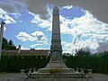
War memorial

covered public scales


Economy and Infrastructure
Agriculture and forestry only play a subordinate role in the community. There are still three farms that keep dairy cattle and cattle, and Forêt Clean is a smaller forest operation (as of 2017). In addition to handicrafts and small businesses, tourism has developed strongly and is based on numerous holiday homes and a campsite.
The D459 trunk road leads through Gemaingoutte from Saint-Dié-des-Vosges over the Col de Sainte-Marie pass to Sainte-Marie-aux-Mines . Since the Maurice-Lemaire tunnel was built a few kilometers to the north, through traffic has decreased. Narrow back roads lead to Bertrimoutier and Ban-de-Laveline . The nearest train station is in the municipality of Raves, four kilometers away, on the Strasbourg – Saint-Dié railway line .
supporting documents
- ↑ history on gemaingoutte.fr
- ↑ Gemaingoutte on cassini.ehess.fr
- ↑ Gemaingoutte on insee.fr
- ↑ Companies on annuaire-mairie.fr (French)