Hurbache
| Hurbache | ||
|---|---|---|
|
|
||
| region | Grand Est | |
| Department | Vosges | |
| Arrondissement | Saint-Dié-des-Vosges | |
| Canton | Raon-l'Étape | |
| Community association | Saint-Dié-des-Vosges | |
| Coordinates | 48 ° 21 ′ N , 6 ° 56 ′ E | |
| height | 304-592 m | |
| surface | 9.93 km 2 | |
| Residents | 320 (January 1, 2017) | |
| Population density | 32 inhabitants / km 2 | |
| Post Code | 88210 | |
| INSEE code | 88245 | |
 Mairie Hurbache |
||
Hurbache (German originally: Hurbach (1187)) is a French commune with 320 inhabitants (as of January 1, 2017) in the Vosges department in the Grand Est region . It belongs to the Arrondissement of Saint-Dié-des-Vosges and the municipality of Saint-Dié-des-Vosges . The inhabitants call themselves Hurbachois (es) .
geography

Hurbache is located in the Vosges on the Hure River , about ten kilometers north of Saint-Dié-des-Vosges . Neighboring communities of Hurbache are Moyenmoutier in the north, Denipaire in the east, Saint-Dié-des-Vosges in the south and La Voivre in the west.
North and south of the Huretal, the wooded terrain rises to heights of over 400 m. The highest point in the municipality is a 592 m high rock formation in the extreme south.
Population development
| 1962 | 1968 | 1975 | 1982 | 1990 | 1999 | 2006 | 2017 | ||
|---|---|---|---|---|---|---|---|---|---|
| 256 | 261 | 232 | 227 | 253 | 282 | 308 | 320 | ||
| Sources: Cassini and INSEE | |||||||||
Attractions
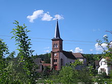
The 19th century church of Saint-Étienne-et-Saint-Gengoult replaced a previous building that had been destroyed during the French Revolution.
The "Celtic camp Bure" ( Camp celtique de la Bure ), later also called "Roman camp" by the locals, is located on a hill of a sandstone ledge on the border with the municipality of Saint-Dié . The square with a monumental Jupiter statue dominated the Via salinatorum , which led from Étival to Saales . Excavations around the camp unearthed numerous ancient and Merovingian artifacts, for example wall remains, two large anvils and blacksmith slag. The Celtic camp has been classified as a Monument historique since 1982 .
Economy and Infrastructure
Six farms are located in the municipality (dairy farming, horse breeding).
The D 32 road from Étival-Clairefontaine to the Alsatian Saales runs through the municipality of Hurbache . Four kilometers west of Hurbache there is a connection to the motorway-like Route nationale 59 from Lunéville to Sélestat .
supporting documents
- ↑ Hurbache on cassini.ehess.fr
- ↑ Hurbache on insee.fr
- ^ Entry in the Base Mérimée of the Ministry of Culture. Retrieved November 10, 2015 (French).
- ↑ Farms on annuaire-mairie.fr (French)


