
Hall
| Hall | ||
|---|---|---|

|
|
|
| region | Grand Est | |
| Department | Bas-Rhin | |
| Arrondissement | Molsheim | |
| Canton | Dirty | |
| Community association | Vallée de la Bruche | |
| Coordinates | 48 ° 21 ' N , 7 ° 6' E | |
| height | 517-831 m | |
| surface | 9.88 km 2 | |
| Residents | 837 (January 1, 2017) | |
| Population density | 85 inhabitants / km 2 | |
| Post Code | 67420 | |
| INSEE code | 67421 | |
| Website | http://www.mairie-saales.fr/ | |
 Mairie Saales |
||

The French commune of Saales (1915 officially introduced German spelling: Saal ) is located in the Vosges in the Bas-Rhin department in the Grand Est region (until 2015 Alsace ). Saales has 837 inhabitants (as of January 1, 2017) and was the main town (chief lieu) of the canton of the same name from 1790 to 2015 and has been part of the canton of Mutzig since then .
geography
The village is located in the valley of the Bruche (German Breusch ), right on the border with the Vosges department . At just under 550 m above sea level, the town center lies just below the top of the Col de Saales pass , which is 300 meters away and forms part of the watershed between the Breusch and Meurthe catchment areas . The highest of the surrounding mountains is the striking Climont east of the village with its 963 and 965 meter high peaks. But it does not belong to the municipality. The Breusch rises on its south-western slope a few seas beyond the municipal boundary at an altitude of 685 m. On the other hand, the 831 m high Solamont north of the village belongs up to the top of the municipality . Saales is on the railway line 8 of the SNCF subsidiary TER Alsace , which runs from Strasbourg via Molsheim to Saint-Dié-des-Vosges . The winding route leads over the top of the Col de Saales pass, but also has a tunnel further south on the mountain slope. The closest stations are Bourg-Bruche in the northeast and Colroy- Lubine (Département Vosges) in the southeast.
history
The place name comes from the former Via salinaria (Latin name; in French "Route du sel ", in German "Salzstraße"). The earlier spelling was "Saâles". In the course of history, the place has often been the scene of armed conflicts: in 1262 it was cremated by the troops of the Bishop of Strasbourg, in 1525 there were major looting in the course of the Peasants 'War and it also suffered greatly from the Thirty Years' War . In 1743 Saales was granted market rights . In 1790, the canton of Saales was formed - initially in the Vosges department , of which the municipality became the capital. In its convenient location on the relatively low Vosges passes (near Bourg-Bruche there is hardly the Col de Steige to the valley of Giessen in the east near Bourg-Bruche ), Saales was for a long time the location of large annual markets. The border location of the place in the years 1871 to 1918 and the relocation of long-distance traffic by modern means of transport brought these trade fairs down and down.
Population development
| year | 1962 | 1968 | 1975 | 1982 | 1990 | 1999 | 2007 | 2013 |
| Residents | 845 | 905 | 830 | 780 | 779 | 853 | 940 | 820 |
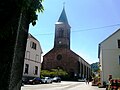
Saint-Barthélémy Church (1846)

Interior of the Saint-Barthélémy church

Mairie

Saales train station


coat of arms
Blazon : a black boar in gold .
Personalities
- Ludwig Bernheim (1884–1974), German administrative lawyer and politician
- Maurice Barthélémy (1871–1922), landowner at Château d'Alteville, mayor of Tarquimpol, member of the state parliament
See also
literature
- Le Patrimoine des Communes du Bas-Rhin. Flohic Editions, Volume 2, Charenton-le-Pont 1999, ISBN 2-84234-055-8 , pp. 1052-1057.