Plaine
| Plaine | ||
|---|---|---|

|
|
|
| region | Grand Est | |
| Department | Bas-Rhin | |
| Arrondissement | Molsheim | |
| Canton | Dirty | |
| Community association | Vallée de la Bruche | |
| Coordinates | 48 ° 25 ' N , 7 ° 9' E | |
| height | 373-900 m | |
| surface | 22.84 km 2 | |
| Residents | 993 (January 1, 2017) | |
| Population density | 43 inhabitants / km 2 | |
| Post Code | 67420 | |
| INSEE code | 67377 | |
| Website | http://www.communedeplaine.com/ | |
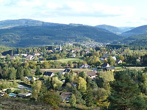
 View of Plaine |
||
Plaine is a French commune with 993 inhabitants (as of January 1, 2017) in the Bas-Rhin department in the Grand Est region ( Alsace until 2015 ).
geography
The community is located south of the Donon massif , above the Breuschtal in the Vosges . The nearby mountains are the Côte de Plaine at 807 meters above sea level and the Chatte Pendue (900 m).
history
The first mention of the settlement comes from a confirmation of the estates of Senones Abbey from 1123.
At the turn of the 18th and 19th centuries, Plaine was the capital of the Canton de la Plaine .
In 1914, in connection with the First World War , the village church built in the 18th century was destroyed. In 1920 the Saint-Arnould church was built.
Population development
| year | 1962 | 1968 | 1975 | 1982 | 1990 | 1999 | 2007 | 2013 |
| Residents | 629 | 711 | 651 | 672 | 709 | 795 | 946 | 986 |
coat of arms
Description : In blue a silver fish with a gold ring in its mouth jumping up to the left .
Economy and Infrastructure
Plaine has the character of a scattered settlement . There is also a swimming pool, country houses, holiday apartments and the "Wacholder" holiday colony. Since not all of the surrounding area is forested, some of it can be used for agriculture.
literature
- Le Patrimoine des Communes du Bas-Rhin. Flohic Editions, Volume 2, Charenton-le-Pont 1999, ISBN 2-84234-055-8 , pp. 1044-1050.


