
Kirchheim (Bas-Rhin)
| Kirchheim | ||
|---|---|---|

|
|
|
| region | Grand Est | |
| Department | Bas-Rhin | |
| Arrondissement | Molsheim | |
| Canton | Molsheim | |
| Community association | Mossig et Vignoble | |
| Coordinates | 48 ° 37 ′ N , 7 ° 30 ′ E | |
| height | 175-237 m | |
| surface | 2.30 km 2 | |
| Residents | 706 (January 1, 2017) | |
| Population density | 307 inhabitants / km 2 | |
| Post Code | 67520 | |
| INSEE code | 67240 | |

Kirchheim ( ) is a French commune with 706 inhabitants (as of January 1, 2017) in the Bas-Rhin department in the Grand Est region (until 2015 Alsace ). She is a member of the Communauté de communes de la Mossig et du Vignoble .
geography
The village is located 22 kilometers west of Strasbourg in the Upper Rhine Plain. The Mossig river flows through the municipality on the northern edge and east of the development.
The viticulture in this region is an important source of income.
history
The village was first mentioned under the name Chilchheim in the 7th century.
From 1871 until the end of the First World War , Kirchheim belonged to the German Empire as part of the realm of Alsace-Lorraine and was assigned to the Molsheim district in the Lower Alsace district .
| year | 1910 | 1962 | 1968 | 1975 | 1982 | 1990 | 1999 | 2006 | 2017 |
| Residents | 349 | 319 | 321 | 438 | 439 | 499 | 513 | 543 | 706 |
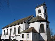
Trinity Church in Kirchheim
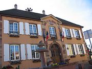
Kirchheim town hall


literature
- Le Patrimoine des Communes du Bas-Rhin. Flohic Editions, Volume 2, Charenton-le-Pont 1999, ISBN 2-84234-055-8 , pp. 1538-1540.