
Grendelbruch
| Grendelbruch | ||
|---|---|---|

|
|
|
| region | Grand Est | |
| Department | Bas-Rhin | |
| Arrondissement | Molsheim | |
| Canton | Molsheim | |
| Community association | Portes de Rosheim | |
| Coordinates | 48 ° 30 ′ N , 7 ° 19 ′ E | |
| height | 399-1,031 m | |
| surface | 14.63 km 2 | |
| Residents | 1,201 (January 1, 2017) | |
| Population density | 82 inhabitants / km 2 | |
| Post Code | 67190 | |
| INSEE code | 67167 | |
 Mairie Grendelbruch |
||

Grendelbruch is a French commune with 1201 inhabitants (as of January 1, 2017) in the Bas-Rhin department in the Grand Est region (until 2015 Alsace ).
geography
The watershed runs through the municipality between the Grendelbach, which flows into the Bruche , and the Magel , which comes from the south and then flows to the east. The area around Grendelbruch, which is part of the Vosges Mountains, is largely forested. To the northeast is the Forêt de Guirbaden .
history
From 1871 until the end of the First World War , Grendelbruch belonged to the German Empire as part of the realm of Alsace-Lorraine and was assigned to the Molsheim district in the Lower Alsace district .
Population development
| year | 1882 | 1910 | 1962 | 1968 | 1975 | 1982 | 1990 | 1999 | 2007 | 2013 |
|---|---|---|---|---|---|---|---|---|---|---|
| Residents | 1,606 | 1,252 | 1,017 | 1,062 | 1.004 | 953 | 918 | 1,127 | 1,228 | 1,265 |
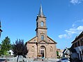
Saint-Philippe & Saint-Jacques church

Former Saint-Pancrace & Saint-Cyriaque Church
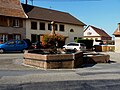
One of the wells in Grendelbruch


See also
literature
- Le Patrimoine des Communes du Bas-Rhin. Flohic Editions, Volume 2, Charenton-le-Pont 1999, ISBN 2-84234-055-8 , pp. 1014-1015.