Saint-Nabor
| Saint-Nabor | ||
|---|---|---|

|
|
|
| region | Grand Est | |
| Department | Bas-Rhin | |
| Arrondissement | Molsheim | |
| Canton | Molsheim | |
| Community association | Portes de Rosheim | |
| Coordinates | 48 ° 27 ' N , 7 ° 25' E | |
| height | 265-630 m | |
| surface | 1.89 km 2 | |
| Residents | 485 (January 1, 2017) | |
| Population density | 257 inhabitants / km 2 | |
| Post Code | 67530 | |
| INSEE code | 67428 | |
| Website | http://saint-nabor.fr/ | |
Saint-Nabor (German Sankt Nabor ) is a French commune near Mont Sainte-Odile in the Bas-Rhin department in the Grand Est region (until 2015 Alsace ). The village belonged to the German Empire from 1871 to 1918 as Sankt Nabor . Today Saint-Nabor has 485 inhabitants (as of January 1, 2017).
history
The development of Saint-Nabor is closely linked to the Niedermünster monastery , the ruins of which are located nearby on the slope of Mount Odile. The place is named after Saint Nabor , a Christian martyr who was beheaded around the year 300.
An eleven kilometer long railway line between Rosheim and Saint-Nabor had been in operation since 1902 . In 1954 the passenger train service was stopped, in 2002 also the freight service.
| year | 1962 | 1968 | 1975 | 1982 | 1990 | 1999 | 2007 | 2017 |
| Residents | 215 | 235 | 246 | 351 | 434 | 479 | 460 | 485 |
Attractions
- Ruins of the Niedermünster monastery
- Parish church of St-Nabor with a tower from the 12th century
literature
- Le Patrimoine des Communes du Bas-Rhin. Flohic Editions, Volume 2, Charenton-le-Pont 1999, ISBN 2-84234-055-8 , pp. 1036-1037.
Web links
Commons : Saint-Nabor - Collection of images, videos and audio files

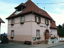
Mairie and school buildings
|

